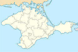
Izobilne, Alushta
Izobilne
Ізобільне · Изобильное · Körbekül | |
|---|---|
 | |
| Coordinates: 44°42′06″N 34°21′16″E / 44.70167°N 34.35444°E | |
| Republic | Crimea |
| Municipality | Alushta Municipality |
| Established | 15th century |
| Population (2001) | 2,305 |
Izobilne (Ukrainian: Ізобільне; Russian: Изобильное, romanized: Izobilnoye), known until 1945 by the Crimean Tatar name of Körbekül (Russian and Ukrainian: Корбек, romanized: Korbek), is a village in Alushta Municipality, Crimea, a region internationally recognised as part of Ukraine but occupied by Russia since 2014.
History
[edit]Körbekül was established in the late 15th century, and was first occupied by the Red Army in January 1918 during the Russian Civil War.[1] The village was depopulated during the deportation of the Crimean Tatars, and renamed to Izobilne.[2]
Izobilne is home to Körbek Cami, a large mosque. Known for its beauty, the mosque's minaret was destroyed in the early 20th century and subsequently closed following the deportation of the Crimean Tatars. In 1994, amidst the 1992–1994 Crimean crisis, the mosque was rebuilt in 2014 with funding from Turkish businessman Murat Ülker. His grandfather was the final imam of the mosque before being forced abroad during the Great Purge.[3]
Demographics
[edit]According to the 2001 Ukrainian census, Izobilne has a population of 2,305.[4] Of this population, 67.68% speaks the Russian language. Crimean Tatar is the second largest language and is spoken by 25.77% of the population. Ukrainian is spoken by 5.34% of the population. [5]
Notable people
[edit]- Mustafa Chachi, collective farm manager
References
[edit]- ^ "Ізобільне, Кримська область" [Izobilne, Crimean Oblast]. History of Cities and Villages of the Ukrainian SSR (in Ukrainian). 2 May 2017. Retrieved 3 July 2024.
- ^ Vladymyrov, Viktor (15 August 2019). "Ізобільне: інжир, гори і гарні пейзажі (фотогалерея)" [Izobilne: Figs, mountains, and beautiful landscapes (photo gallery)]. Radio Free Europe/Radio Liberty (in Ukrainian). Retrieved 3 July 2024.
- ^ Vladymyrov, Viktor (10 January 2020). "Мечети Крыма: Корбек джами – завещание предков (фотогалерея)" [Mosques of Crimea: Körbek Cami – a testament of the ancestors (photo gallery)]. Radio Free Europe/Radio Liberty (in Russian). Retrieved 3 July 2024.
- ^ "Автономна Республіка Крим" [Autonomous Republic of Crimea]. Mashke.org (in Ukrainian). Archived from the original on 10 September 2017. Retrieved 3 July 2024.
- ^ "Таблиця: 19A050501_02_001. Розподіл населення за рідною мовою, Автономна Республіка Крим (1,2,3,4)" [Table 19A050501_02_001: Division of the Population by Native Language, Autonomous Republic of Crimea (1, 2, 3, 4)]. State Statistics Service of Ukraine (in Ukrainian). Archived from the original on 5 March 2016. Retrieved 3 July 2024.


