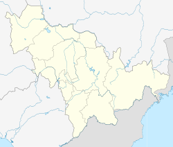
Helong
Appearance
(Redirected from Hwaryong)
Helong
和龙市 · 화룡시 | |
|---|---|
| Coordinates: 42°32′37″N 129°00′10″E / 42.54361°N 129.00278°E | |
| Country | People's Republic of China |
| Province | Jilin |
| Prefecture | Yanbian |
| Seat | Wenhua Subdistrict |
| Area | |
| 5,069.0 km2 (1,957.2 sq mi) | |
| • Urban | 145.00 km2 (55.98 sq mi) |
| Elevation | 451 m (1,480 ft) |
| Population (2017)[1] | |
| 181,000 | |
| • Density | 36/km2 (92/sq mi) |
| • Urban | 95,399 |
| Time zone | UTC+8 (China Standard) |
| Postal code | 133500 |
| Website | http://www.helong.gov.cn/ |
| Helong | |||||||
|---|---|---|---|---|---|---|---|
| Simplified Chinese | 和龙市 | ||||||
| Traditional Chinese | 和龍市 | ||||||
| |||||||
| Chinese Korean name | |||||||
| Chosŏn'gŭl | 화룡시 | ||||||
| |||||||
| South Korean name | |||||||
| Hangul | 허룽시 | ||||||
| |||||||
Helong (simplified Chinese: 和龙; traditional Chinese: 和龍; pinyin: Hélóng; Chosŏn'gŭl: 화룡; Hangul: 허룽) is a county-level city in southeastern Jilin province, Northeast China. It is under the administration of the Yanbian Korean Autonomous Prefecture. In January 2024, several thousand North Korean migrant workers in the city initiated a series of protests over withheld payments.
Administrative divisions
[edit]Helong has three subdistricts and eight towns.[2]
Subdistricts:
- Wenhua Subdistrict (文化街道 / 문화가도)
- Minhui Subdistrict (民惠街道 / 민혜가도)
- Guangming Subdistrict (光明街道 / 광명가도)
Towns:
- Toudao (头道镇 / 두도진)
- Bajiazi (八家子镇 / 팔가자진)
- Fudong (福洞镇 / 복동진)
- Xicheng (西城镇 / 서성진)
- Nanping (南坪镇 / 남평진)
- Longcheng (龙城镇 / 용성진)
- Dongcheng (东城镇 / 동성진)
- Chongshan (崇善镇 / 숭선진)
Climate
[edit]| Climate data for Helong, elevation 476 m (1,562 ft), (1991–2020 normals, extremes 1981–2010) | |||||||||||||
|---|---|---|---|---|---|---|---|---|---|---|---|---|---|
| Month | Jan | Feb | Mar | Apr | May | Jun | Jul | Aug | Sep | Oct | Nov | Dec | Year |
| Record high °C (°F) | 10.7 (51.3) |
16.5 (61.7) |
22.3 (72.1) |
31.4 (88.5) |
32.7 (90.9) |
35.7 (96.3) |
36.2 (97.2) |
35.9 (96.6) |
32.6 (90.7) |
29.5 (85.1) |
23.4 (74.1) |
14.0 (57.2) |
36.2 (97.2) |
| Mean daily maximum °C (°F) | −5.9 (21.4) |
−1.8 (28.8) |
5.0 (41.0) |
14.2 (57.6) |
20.6 (69.1) |
24.1 (75.4) |
26.6 (79.9) |
26.1 (79.0) |
21.6 (70.9) |
14.5 (58.1) |
4.0 (39.2) |
−3.9 (25.0) |
12.1 (53.8) |
| Daily mean °C (°F) | −12.4 (9.7) |
−8.3 (17.1) |
−1.2 (29.8) |
7.2 (45.0) |
13.6 (56.5) |
18.0 (64.4) |
21.1 (70.0) |
20.4 (68.7) |
14.4 (57.9) |
7.1 (44.8) |
−2.0 (28.4) |
−9.9 (14.2) |
5.7 (42.2) |
| Mean daily minimum °C (°F) | −17.7 (0.1) |
−14.1 (6.6) |
−7.0 (19.4) |
0.7 (33.3) |
7.3 (45.1) |
12.6 (54.7) |
16.5 (61.7) |
15.8 (60.4) |
8.4 (47.1) |
0.8 (33.4) |
−7.2 (19.0) |
−15 (5) |
0.1 (32.2) |
| Record low °C (°F) | −31.5 (−24.7) |
−27.4 (−17.3) |
−23.5 (−10.3) |
−10.6 (12.9) |
−3.7 (25.3) |
4.2 (39.6) |
7.2 (45.0) |
5.1 (41.2) |
−3.4 (25.9) |
−12.4 (9.7) |
−22.9 (−9.2) |
−28.5 (−19.3) |
−31.5 (−24.7) |
| Average precipitation mm (inches) | 3.8 (0.15) |
7.5 (0.30) |
12.0 (0.47) |
24.2 (0.95) |
66.7 (2.63) |
84.9 (3.34) |
128.3 (5.05) |
126.0 (4.96) |
58.7 (2.31) |
22.6 (0.89) |
17.4 (0.69) |
6.6 (0.26) |
558.7 (22) |
| Average precipitation days (≥ 0.1 mm) | 3.2 | 4.0 | 6.5 | 8.5 | 14.6 | 15.5 | 15.8 | 15.3 | 9.6 | 6.2 | 6.2 | 4.4 | 109.8 |
| Average snowy days | 6.6 | 6.9 | 9.1 | 4.4 | 0.2 | 0 | 0 | 0 | 0 | 2 | 7.8 | 7.8 | 44.8 |
| Average relative humidity (%) | 55 | 50 | 48 | 48 | 58 | 71 | 79 | 81 | 74 | 58 | 56 | 55 | 61 |
| Mean monthly sunshine hours | 175.4 | 182.8 | 214.2 | 203.1 | 210.0 | 191.1 | 180.3 | 191.2 | 206.3 | 201.2 | 159.7 | 153.4 | 2,268.7 |
| Percent possible sunshine | 60 | 61 | 58 | 51 | 46 | 42 | 39 | 45 | 56 | 59 | 55 | 55 | 52 |
| Source: China Meteorological Administration[3][4] | |||||||||||||
References
[edit]- ^ a b Ministry of Housing and Urban-Rural Development, ed. (2019). China Urban Construction Statistical Yearbook 2017. Beijing: China Statistics Press. p. 50. Archived from the original on 18 June 2019. Retrieved 11 January 2020.
- ^ "延边朝鲜族自治州-行政区划网 www.xzqh.org" (in Chinese). xzqh.org. Retrieved 2011-04-28.
- ^ 中国气象数据网 – WeatherBk Data (in Simplified Chinese). China Meteorological Administration. Retrieved 7 July 2023.
- ^ 中国气象数据网 (in Simplified Chinese). China Meteorological Administration. Retrieved 7 July 2023.
External links
[edit]

