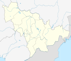
Helong
Appearance
Helong
和龙市 · 화룡시 | |
|---|---|
| Coordinates: 42°32′37″N 129°00′10″E / 42.54361°N 129.00278°E | |
| Country | People's Republic of China |
| Province | Jilin |
| Prefecture | Yanbian |
| Seat | Wenhua Subdistrict |
| Area | |
| 5,069.0 km2 (1,957.2 sq mi) | |
| • Urban | 145.00 km2 (55.98 sq mi) |
| Elevation | 451 m (1,480 ft) |
| Population (2017)[1] | |
| 181,000 | |
| • Density | 36/km2 (92/sq mi) |
| • Urban | 95,399 |
| Time zone | UTC+8 (China Standard) |
| Postal code | 133500 |
| Website | http://www.helong.gov.cn/ |
| Helong | |||
|---|---|---|---|
| Simplified Chinese | 和龙市 | ||
| Traditional Chinese | 和龍市 | ||
| |||
| Chinese Korean name | |||
| Chosŏn'gŭl | 화룡시 | ||
| |||
| South Korean name | |||
| Hangul | 허룽시 | ||
| |||
Helong (simplified Chinese: 和龙; traditional Chinese: 和龍; pinyin: Hélóng; Chosŏn'gŭl: 화룡; Hangul: 허룽) is a county-level city in southeastern Jilin province, Northeast China. It is under the administration of the Yanbian Korean Autonomous Prefecture.
Administrative divisions
[edit]Helong has three subdistricts and eight towns.[2]
Subdistricts:
- Wenhua Subdistrict (文化街道 / 문화가도)
- Minhui Subdistrict (民惠街道 / 민혜가도)
- Guangming Subdistrict (光明街道 / 광명가도)
Towns:
- Toudao (头道镇 / 두도진)
- Bajiazi (八家子镇 / 팔가자진)
- Fudong (福洞镇 / 복동진)
- Xicheng (西城镇 / 서성진)
- Nanping (南坪镇 / 남평진)
- Longcheng (龙城镇 / 용성진)
- Dongcheng (东城镇 / 동성진)
- Chongshan (崇善镇 / 숭선진)
Climate
[edit]| Climate data for Helong, elevation 476 m (1,562 ft), (1991–2020 normals, extremes 1981–2010) |
|---|
References
[edit]- ^ Jump up to: a b Ministry of Housing and Urban-Rural Development, ed. (2019). China Urban Construction Statistical Yearbook 2017. Beijing: China Statistics Press. p. 50. Archived from the original on 18 June 2019. Retrieved 11 January 2020.
- ^ "延边朝鲜族自治州-行政区划网 www.xzqh.org" (in Chinese). xzqh.org. Retrieved 2011-04-28.
- ^ 中国气象数据网 – WeatherBk Data (in Simplified Chinese). China Meteorological Administration. Retrieved 7 July 2023.
- ^ 中国气象数据网 (in Simplified Chinese). China Meteorological Administration. Retrieved 7 July 2023.
External links
[edit]


