Huancabamba province
Appearance
(Redirected from Huancabamba Province)
Huancabamba | |
|---|---|
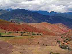
 Soil erosion south of Huancabamba | |
 Location of Huancabamba in the Piura Region | |
| Country | Peru |
| Region | Piura |
| Founded | March 20, 1861 |
| Capital | Huancabamba |
| Government | |
| • Mayor | Marco Napoleón Velasco García |
| Area | |
• Total | 4,254.14 km2 (1,642.53 sq mi) |
| Elevation | 1,929 m (6,329 ft) |
| Population | |
• Total | 123,456 |
| • Density | 29/km2 (75/sq mi) |
| UBIGEO | 2003 |
Huancabamba Province is a landlocked province in the Piura Region in northwestern Peru. The province is the easternmost in the region.[1]
Boundaries
[edit]- North Ecuador
- East Cajamarca Region
- South Lambayeque Region
- West Ayabaca Province
Political division
[edit]The Province has an area of 4,254.14 square kilometers (1,642.53 sq mi) and is divided into eight districts.[2]
- Huancabamba
- Canchaque
- El Carmen de la Frontera
- Huarmaca
- Lalaquiz
- San Miguel de El Faique
- Sondor
- Sondorillo
Population
[edit]The province has an approximate population of 125,000 residents.
Capital
[edit]The capital of the province is the city of Huancabamba.
This province is famous by Waringa Lake (Laguna de Huaringas).
