Horní Počaply
Horní Počaply | |
|---|---|
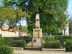
 Monument to the fallen in both World Wars | |
| Coordinates: 50°25′28″N 14°23′24″E / 50.42444°N 14.39000°E | |
| Country | |
| Region | Central Bohemian |
| District | Mělník |
| First mentioned | 1288 |
| Area | |
• Total | 12.39 km2 (4.78 sq mi) |
| Elevation | 160 m (520 ft) |
| Population (2024-01-01)[1] | |
• Total | 1,258 |
| • Density | 100/km2 (260/sq mi) |
| Time zone | UTC+1 (CET) |
| • Summer (DST) | UTC+2 (CEST) |
| Postal code | 277 03 |
| Website | www |
Horní Počaply is a municipality and village in Mělník District in the Central Bohemian Region of the Czech Republic. It has about 1,300 inhabitants.
Administrative parts
[edit]The village of Křivenice is an administrative part of Horní Počaply.
Geography
[edit]Horní Počaply is located about 8 kilometres (5 mi) northwest of Mělník and 34 km (21 mi) north of Prague. It lies in a flat landscape of the Lower Ohře Table. The municipality is situated on the left bank of the Elbe River.
History
[edit]The first written mention of Horní Počaply is in a deed of King Wenceslaus II from 1288. The village was divided into two parts and one was part of the Dolní Beřkovice estate from 1465, the other belonged to the Horní Beřkovice estate. This lasted until 1850, when an independent municipality was established.[2]
Demographics
[edit]
|
|
| ||||||||||||||||||||||||||||||||||||||||||||||||||||||
| Source: Censuses[3][4] | ||||||||||||||||||||||||||||||||||||||||||||||||||||||||
Transport
[edit]Horní Počaply is located on the railway line Prague–Ústí nad Labem.[5]
Sights
[edit]The main landmark of Horní Počaply is the Church of the Assumption of the Virgin Mary. It is originally a Gothic church from the 13th or 14th century, rebuilt in the neo-Gothic style in 1869–1871.[6]
References
[edit]- ^ "Population of Municipalities – 1 January 2024". Czech Statistical Office. 2024-05-17.
- ^ "Historie obce" (in Czech). Obec Horní Počaply. Retrieved 2023-03-18.
- ^ "Historický lexikon obcí České republiky 1869–2011" (in Czech). Czech Statistical Office. 2015-12-21.
- ^ "Population Census 2021: Population by sex". Public Database. Czech Statistical Office. 2021-03-27.
- ^ "Detail stanice Horní Počaply" (in Czech). České dráhy. Retrieved 2024-02-26.
- ^ "Kostel Nanebevzetí Panny Marie" (in Czech). National Heritage Institute. Retrieved 2023-03-18.
External links
[edit]


