Hilpertsau
Appearance
Hilpertsau | |
|---|---|
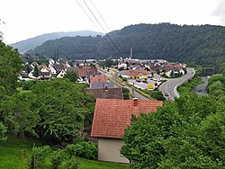
 View over Hilpertsau | |
| Coordinates: 48°44′20″N 8°20′51″E / 48.73889°N 8.34750°E | |
| Country | Germany |
| State | Baden-Württemberg |
| Admin. region | Karlsruhe |
| District | Rastatt |
| Town | Gernsbach |
| Area | |
• Total | 3.9454 km2 (1.5233 sq mi) |
| Elevation | 182 m (597 ft) |
| Population | |
• Total | 1,000 |
| • Density | 250/km2 (660/sq mi) |
| Time zone | UTC+01:00 (CET) |
| • Summer (DST) | UTC+02:00 (CEST) |
| Postal codes | 76593 |
| Dialling codes | 07224 |
Hilpertsau is a village in Baden-Württemberg, Germany. It is administratively part of the town of Gernsbach in the Rastatt district.
Geography
[edit]The village is located south of Gernsbach in the Murg Valley.
History
[edit]The first documented mention of Hilpertsau is as 'Hilboltzowe' in the year 1339–1340.[2] On April 1, 1970, Hilpertsau merged with Obertsrot to form the Obertsrot community, which was then incorporated into the town of Gernsbach on July 1, 1974.[3]
References
[edit]- ^ "Hilpertsau". gernsbach.de. Stadt Gernsbach. Retrieved 29 September 2022.
- ^ "Hilpertsau". gernsbach.de. Stadt Gernsbach. Retrieved 29 September 2022.
- ^ Historisches Gemeindeverzeichnis für die Bundesrepublik Deutschland : Namens-, Grenz- und Schlüsselnummernänderungen bei Gemeinden, Kreisen und Regierungsbezirken vom 27.5.1970 bis 31.12.1982. Stuttgart: Kohlhammer. 1983. p. 483. ISBN 3170032631.


