Húnavatnshreppur
Appearance
This article needs additional citations for verification. (July 2022) |
Húnavatnshreppur | |
|---|---|
Former municipality | |
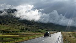
 Skyline of Húnavatnshreppur | |
 Location of the municipality | |
| Coordinates: 65°30′57″N 20°23′18″W / 65.5158316°N 20.3883425°W | |
| Country | Iceland |
| Region | Northwestern Region |
| Constituency | Northwest Constituency |
| Municipality | Húnabyggð |
| Government | |
| • Manager | Einar Kristján Jónsson |
| Area | |
• Total | 3,817 km2 (1,474 sq mi) |
| Population | |
• Total | 409 |
| • Density | 0.11/km2 (0.3/sq mi) |
| Website | hunavatnshreppur |
Húnavatnshreppur (Icelandic pronunciation: [ˈhuːnaˌvasːˌr̥ɛhpʏr̥] ) is a former rural municipality located in northwestern Iceland.
History
[edit]The municipality was formed on 1 January 2006 by the union of the former municipalities of Sveinsstaðahreppur [ˈsveinsˌstaːðaˌr̥ehpʏr̥], Torfalækjarhreppur [ˈtʰɔrvaˌlaiːcar̥ˌr̥ɛhpʏr̥], Svínavatnshreppur [ˈsviːnaˌvasːˌr̥ɛhpʏr̥] and Bólstaðarhlíðarhreppur [ˈpoulˌstaːðarˌl̥iːðar̥ˌr̥ɛhpʏr̥]. In 2022, the municipality merged with Blönduós to form Húnabyggð.[1]
Geography
[edit]Húnavatn is one of the largest Icelandic municipalities. Its southern borders touch the glaciers of Hofsjökull and Langjökull. In the south are situated also the hot springs in Hveravellir.
References
[edit]- ^ Árni Sæberg. "Samþykktu að sameinað sveitarfélag fái nafnið Húnabyggð - Vísir". visir.is (in Icelandic).

