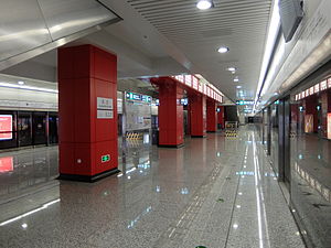
Guanzhuang station (Line 15)
 Platform | |||||||||||
| General information | |||||||||||
| Location | North Guanzhuang Road and Beihuqu West Road Datun Subdistrict, Chaoyang District, Beijing China | ||||||||||
| Operated by | Beijing Mass Transit Railway Operation Corporation Limited | ||||||||||
| Line(s) | Line 15 | ||||||||||
| Platforms | 2 (1 island platform) | ||||||||||
| Tracks | 2 | ||||||||||
| Construction | |||||||||||
| Structure type | Underground | ||||||||||
| Accessible | Yes | ||||||||||
| History | |||||||||||
| Opened | December 28, 2014 | ||||||||||
| Services | |||||||||||
| |||||||||||
| |||||||||||
Guanzhuang station[2] (simplified Chinese: 关庄站; traditional Chinese: 關莊站; pinyin: Guānzhuāng zhàn) is a station on Line 15 of the Beijing Subway.[3] It was opened on December 28, 2014.[4]
Name conflict
[edit]This station had the same English name as a station on the Batong line, also part of the Beijing Subway system. In Chinese this is not a problem as the station on Line 15 is called 关庄 and the one on the Batong Line is called 管庄, but the government policy is to create English names from the pinyin transliteration of Chinese language, but without the tone markers; thus 关庄 (Guānzhuāng) and 管庄 (Guǎnzhuāng) are both rendered as Guanzhuang, making them look identical.
In December 2019, the 管庄 (Guǎnzhuāng) station on Batong line changed spelling to Guaanzhuang.[1]
Station layout
[edit]The station has an underground island platform.
Exits
[edit]There are 3 exits, lettered A, B, and C. Exit B is accessible.
Gallery
[edit]-
Concourse
-
Platform
References
[edit]- ^ a b "JPG格式线路图下载 北京地铁官方网站". Archived from the original on 2022-12-31.
- ^ "JPG格式线路图下载". Archived from the original on 2024-01-02. Retrieved 2024-05-11.
- ^ 北京朝阳区关庄站. Retrieved November 8, 2012.
- ^ 北京地铁15号线开工 明年10月可实现洞通. Beijing Times. Archived from the original on December 30, 2014. Retrieved November 8, 2012.
40°00′04″N 116°25′51″E / 40.001134°N 116.430947°E

![Guanzhuang[1] is located in Beijing](http://upload.wikimedia.org/wikipedia/commons/thumb/f/f0/China_Beijing_adm_location_map.svg/240px-China_Beijing_adm_location_map.svg.png)

