Geita District
Geita District | |
|---|---|
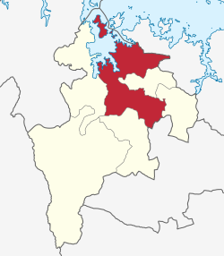
 Geita District's location within Geita Region. | |
| Coordinates: 02°55′00″S 032°15′00″E / 2.91667°S 32.25000°E | |
| Country | |
| Region | Geita |
| District | Geita |
| Population (2022)[1] | |
• Total | 1,035,214 |
| Time zone | UTC+3 (EAT) |
| Postcode | 30xxx |
| Area code | 028 |
| Website | District website |
Geita District is located in the Geita Region of Tanzania.[2] According to the 2022 census, the population of the district was 1,035,214.[3][1] The district is bordered to the east by Mwanza Region and Nyang'hwale District, to the south by Shinyanga Region and Mbogwe District, and to the west by Chato District.
History
[edit]Prior to the creation of the Geita Region in March 2012,[4] the Geita District was part of the Mwanza Region.[5]
Transport
[edit]Road
[edit]Paved trunk road T4 from Mwanza to Bukoba passes through the district from east to west.[6]
Economy
[edit]Mining
[edit]Geita Gold Mine is located within Geita District, 4 km west of the town of Geita. The mine is currently being owned and managed by AngloGold Ashanti.[7]
Tourism
[edit]Rubondo Island National Park is located on an island in Lake Victoria that is a part of Geita District. It can be reached by ferry from Nkome, a village in the north of the district.[8]
Wards
[edit]As of the 2012 census, Geita District council was divided administratively into 35 wards:[1]
- Bugalama
- Bugulula
- Bujula
- Bukoli
- Bukondo
- Bulela
- Bung'wangoko
- Busanda
- Butobela
- Chigunga
- Ihanamilo
- Isulwabutundwe
- Kagu
- Kakubilo
- Kalangalala
- Kamena
- Kamhanga
- Kasamwa
- Kaseme
- Katoma
- Katoro
- Lubanga
- Lwamgasa
- Lwezera
- Mtakuja
- Nkome
- Nyachiluluma
- Nyakagomba
- Nyakamwaga
- Nyamalimbe
- Nyamigota
- Nyanguku
- Nyarugusu
- Nzera
- Senga
References
[edit]- ^ a b c Population Distribution by Administrative Units, United Republic of Tanzania, 2013 Archived May 2, 2013, at the Wayback Machine
- ^ "Tanzania: State Gazettes New Regions, Districts". Daily News. Dar es Salaam, Tanzania. 9 March 2012. Archived from the original on August 23, 2012.
- ^ "Geita Rural (District, Tanzania) - Population Statistics, Charts, Map and Location". www.citypopulation.de. Retrieved 2024-02-10.
- ^ Staff (9 March 2012). "Tanzania: State Gazettes New Regions, Districts". Daily News. Dar es Salaam, Tanzania. Archived from the original on August 23, 2012.
- ^ "Historia". Mkoa wa Geita (in Swahili). Geita. Archived from the original on 17 June 2022. Retrieved 14 July 2022.
- ^ "Geita Roads Network" (PDF). Tanroads. Archived from the original (PDF) on 2017-02-02. Retrieved 21 September 2016.
- ^ "AngloGold Ashanti in Tanzania". AngloGold Ashanti. Archived from the original on 2016-09-11. Retrieved 21 September 2016.
- ^ "Rubondo Island National Park". Tanzania National Parks. Archived from the original on 29 September 2012. Retrieved 21 September 2016.
