
Ghadames
Ghadames
غدامس | |
|---|---|
Town | |
 .jpg)  Clockwise from top: Ghadames Mosque, Old Town, Old Town street view | |
 Ghadames Location in Libya | |
| Coordinates: 30°8′N 9°30′E / 30.133°N 9.500°E | |
| Country | |
| Region | Tripolitania |
| District | Nalut |
| Elevation | 1,932 ft (589 m) |
| Population | |
• Estimate (2011) | 10,000 |
| Time zone | UTC+2 (EET) |
| License Plate Code | 17 |
 | |
| Official name | Old Town of Ghadamès |
| Type | Cultural |
| Criteria | v |
| Designated | 1986 |
| Reference no. | [3] |
| Region | Arab States |
Ghadames or Ghadamis /ɡəˈdæmɪs/ (Ghadamsi: ⵄⴰⴷⴻⵎⴻⵙ / Ɛadēməs [ʕadeːməs], Arabic: غدامس, Italian: Gadames) is an oasis town in the Nalut District of the Tripolitania region in northwestern Libya.
Ghadamès, known as 'the pearl of the desert', stands in an oasis. It is one of the oldest pre-Saharan cities and an outstanding example of a traditional settlement. Its domestic architecture is characterized by a vertical division of functions: the ground floor used to store supplies; the first floor is for the family, overhanging covered alleys that create what is almost an underground network of passageways; and, at the top, open-air terraces reserved for the women.[4]
Geography
[edit]Ghadames lies roughly 462 km (287 mi) to the southwest of Tripoli, near the borders with Algeria and Tunisia. Ghadames borders Illizi Province, Algeria and Tataouine Governorate, Tunisia.
The oasis has a population of around 10,000, mainly Berbers. The old part of the town, which is surrounded by a city wall, has been declared a UNESCO World Heritage site. Each of the seven clans that used to live in this part of the town had its own district, of which each had a public place where festivals could be held.
Climate
[edit]Ghadames has a hot desert climate (Köppen climate classification BWh) with hot summers as average high temperature is around 41 °C (105.8 °F) in July, the hottest month of the year as well as cool winters (with high diurnal variation). The town receives little precipitation throughout the year as average annual precipitation is only 73.1 mm (1.30 in).
| Climate data for Ghadames (1991–2020, extremes 1913–2020) | |||||||||||||
|---|---|---|---|---|---|---|---|---|---|---|---|---|---|
| Month | Jan | Feb | Mar | Apr | May | Jun | Jul | Aug | Sep | Oct | Nov | Dec | Year |
| Record high °C (°F) | 29.0 (84.2) |
37.5 (99.5) |
38.8 (101.8) |
44.0 (111.2) |
45.3 (113.5) |
47.0 (116.6) |
48.0 (118.4) |
47.5 (117.5) |
45.0 (113.0) |
43.3 (109.9) |
38.0 (100.4) |
33.0 (91.4) |
48.0 (118.4) |
| Mean daily maximum °C (°F) | 18.2 (64.8) |
20.7 (69.3) |
25.3 (77.5) |
30.5 (86.9) |
35.7 (96.3) |
39.7 (103.5) |
41.5 (106.7) |
40.8 (105.4) |
37.7 (99.9) |
32.1 (89.8) |
24.4 (75.9) |
19.0 (66.2) |
30.5 (86.9) |
| Daily mean °C (°F) | 11.4 (52.5) |
13.7 (56.7) |
18.1 (64.6) |
22.9 (73.2) |
27.9 (82.2) |
31.7 (89.1) |
33.4 (92.1) |
32.9 (91.2) |
30.3 (86.5) |
24.9 (76.8) |
17.5 (63.5) |
12.5 (54.5) |
23.1 (73.6) |
| Mean daily minimum °C (°F) | 4.6 (40.3) |
6.7 (44.1) |
10.9 (51.6) |
15.4 (59.7) |
20.2 (68.4) |
23.7 (74.7) |
25.2 (77.4) |
25.0 (77.0) |
22.9 (73.2) |
17.7 (63.9) |
10.6 (51.1) |
5.9 (42.6) |
15.7 (60.3) |
| Record low °C (°F) | −2.0 (28.4) |
−3.0 (26.6) |
1.5 (34.7) |
3.4 (38.1) |
9.8 (49.6) |
14.4 (57.9) |
17.0 (62.6) |
16.7 (62.1) |
11.5 (52.7) |
7.5 (45.5) |
−1.0 (30.2) |
−2.5 (27.5) |
−3.0 (26.6) |
| Average precipitation mm (inches) | 4.9 (0.19) |
5.2 (0.20) |
5.3 (0.21) |
2.4 (0.09) |
1.8 (0.07) |
0.5 (0.02) |
0.0 (0.0) |
0.2 (0.01) |
2.9 (0.11) |
3.0 (0.12) |
3.2 (0.13) |
4.8 (0.19) |
34.2 (1.35) |
| Average precipitation days (≥ 1.0 mm) | 0.8 | 0.8 | 0.8 | 0.5 | 0.4 | 0.0 | 0.0 | 0.0 | 0.4 | 0.6 | 0.7 | 0.9 | 5.9 |
| Average relative humidity (%) | 52 | 41 | 36 | 28 | 26 | 22 | 22 | 23 | 29 | 35 | 47 | 53 | 34 |
| Mean monthly sunshine hours | 248.0 | 240.1 | 257.3 | 273.0 | 313.1 | 309.0 | 372.0 | 353.4 | 273.0 | 263.5 | 246.0 | 232.5 | 3,380.9 |
| Mean daily sunshine hours | 8.0 | 8.5 | 8.3 | 9.1 | 10.1 | 10.3 | 12.0 | 11.4 | 9.1 | 8.5 | 8.2 | 7.5 | 9.3 |
| Source 1: NOAA[5] | |||||||||||||
| Source 2: Deutscher Wetterdienst (extremes and humidity),[6] Arab Meteorology Book (sun only)[7] | |||||||||||||
History
[edit]Ancient eras
[edit]
It has been suggested, based on archaeological evidence, that this area has been settled since the 4th millennium B.C., and is one of the oldest pre-Saharan settlements. Its situation near a water source in the middle of a desert would have made it an important spot for anyone seeking to settle in the area.
The first written records about Ghadames date from the Roman period when the settlement was known as Cydamus, from which modern Ghadames derives its name. In the 1st century BC, the Roman proconsul Lucius Cornelius Balbus invaded Cydamus during the reign of emperor Augustus.[8] A permanent Roman garrison was established during the reign of Septimius Severus, and the emperor may have visited the settlement around AD 202.[9] However, the Romans withdrew from the area a few decades later during the Crisis of the Third Century.
During the 6th century, a bishop lived in the oasis, after the population had been converted to Christianity by Byzantine missionaries. It became a stronghold of the Donatist heresy until its conquest by Muslim Arabs.
During the late 7th century, Ghadames was ruled by the Muslim Arabs. The population quickly converted to Islam and Ghadames played an important role as base for the Trans-Saharan trade until the 19th century.
The 12th century geographer Abu Hamid al-Gharnati included Ghadamis among the countries of Sudan (i.e., countries of black people), a hypothesis that Saad considers possible, as Ghadamis always had settlers representing him in Timbuktu.[10]
Ghadamis was an important town in the trans-Saharan slave trade.[11][12]
Etymology
[edit]The etymology of the name Ghadames is very closely linked with its history. It is believed that the name Ghadames is originally connected to the name of the ancient Berber tribe of Tidamensi, a tribe from Fezzan. It is also believed that the name Tidamensi was corrupted by the invading Romans to form the name Cydamus, which in turn gave way to the name Ghadames.[8]
1900s–present
[edit]In October 1911, shortly after the Italo-Turkish War broke out, Ghadames was occupied by Italian soldiers marching from Tripoli. However, Italy's hold on the city was interrupted several times until June 1915, when a general rising throughout Libya caused the Italian garrison to retreat from Ghadames to the stronghold of Tripoli. Effective control over the city was restored in December 1918, but rebellion throughout Fezzan kept Ghadames in a state of emergency until 1923.
In 1943, Free French forces occupied Ghadames and its surrounding area in the southern part of the former Italian colony of Libya, forming the Military Territory of Fezzan-Ghadames until Libyan independence in 1951. Ghadames was made the territory's capital during this time.
In the 1970s, the government built new houses outside of the old part of the town. However, many inhabitants return to the old part of the town during the summer, as its architecture provides better protection against the heat.
That same time, director Moustapha Akkad chose Ghadames as a filming location for interior scenes of the city of Medina in The Message, an Islamic epic drama film.
During the Libyan Civil War, National Transitional Council forces entered the town on 30 August 2011,[citation needed] which had been under siege by NTC forces since the beginning of the conflict. Until 2011, the city was under control by independent Tuareg troops.[13] After being captured by the Libyan National Army, the entire Tuareg community was forced to flee in an act of ethnic cleansing.[14][15]
Old Town of Ghadames
[edit]This section needs expansion. You can help by adding to it. (March 2011) |
Location
[edit]The old town of Ghadames is located in an oasis about 600 km south-west of Tripoli near Libya’s border with Algeria [16].
Architecture
[edit]It has maintained a high level of authenticity by not making changes to the design, materials and workmanship of its buildings, and preserving the balanced environmental system. This results from an awareness of the Ghadamès community of the urban and architectural value of the city and the importance of the continuity of its cultural traditions, which continues to influence the design of modern housing outside of the historic city [17].
In the town, streets, alleys and passage ways are curved. Houses are located on the street, alleys and passage ways. Each neighborhood had its properly located and sized public places including a main mosque, a number of mosques for men, women and children, zawias, Quranic schools and public squares utilized for different cultural activities. Bench-like sitting places for different age groups are placed at strategic locations along the streets, alleys and passage ways. The streets, alleys and passage ways are covered except for light holes regularly spaced along them. The cities neighborhoods contain over 1600 buildings comprising about 1350 houses, 242 public and private (shops, stores, etc.) buildings, 23 mosques, 10 zawias, 10 Quranic schools, 7 entrances and 7 gates. [18].
Ghadamsi houses are practically identical in their architectural design which is a perfect response to the human needs and scale and to the economic and environmental constraints both on the individual and community levels. They differ only in areas which range from 30 to 80 m2 with larger houses belonging to larger andor richer families. A house is typically constructed in four levels with a total height of about 12 m. The ground floor consists of the entrance and the farming tools store. Stairs from this floor lead to the bathroom and thence to the living room in the first floor. The living room which is the most used space in the house is heavily decorated with gypsum works, ornaments, brass works, mirrors for extra space, light reflection and personal use, and local handicrafts making it a mini-museum with eternal attraction for family and guests. It also contains small storage spaces for different purposes. It is surrounded by the Qubba, a socio-religious mini- room, main bedroom and boys room. The split third floor consists of girls room while the fourth split level contains the food storage rooms. The kitchen is located on the roof to allow for smoke to raise and disperse into the atmosphere away from the living areas below. Every house has a special, more durable wall on its roof which is reserved for women and children to walk on during daytime away from men in accordance with socio-religious norms. Conversely, the outside of the house is very simple with no decorations or markings except for a standard door made of palm-trunk sections thus exhibiting a unique simplicity and equality between residents regardless of socio-economic or other status privileges. Natural lighting of the house during the day and ventilation are secured through a large light hole in the roof projecting into a smaller one in the living room floor thus ensuring that light and air reach all floors. The roof hole is closed during rain and sand storms. Other small "windows" on the outside walls are used for the same purposes. A unique, but common feature of all spaces in the Ghadarnsi buildings is the full respect for human scale. Another is the full utilization of all spaces in the house. This way, the house, although very compact, is quite functional and comfortable at the same time. This compactness translates into minimum materials and energy inputs making the house cost-effective and, thus, available to most if not all families. House walls are laid next to one another in bee-hive like structures. Spaces are intertwined in such a way that units of one house may lie above or below those of other houses. This way, the city acts as one monolithic structure with exceptional abilities to withstand wind forces, dust, heat and cold [19] .
Current Conservation
[edit]The old town, inscribed in 1986 as a UNESCO World Heritage site, was de-populated of its inhabitants throughout the mid-1970s [20]. This occurred after a new town was built next to the historic one, which has resulted in depopulation, less frequent maintenance and a decrease in skilled craftspeople using traditional techniques [20]. This in turn left the old buildings at risk of collapse due to a lack of maintenance.[21] It has been listed on the List of World Heritage in Danger since 2016 among four other sites in Libya, because of damage caused by the Libyan Civil War affecting the country and the threat of further damage it poses.[22] Since then, the State Party in Libya – the Department of Antiquities (DoA) – has been working on updating the official documents to produce the Retrospective Outstanding Universal Values (ROUV) and conservation reports [23].
Gallery
[edit]-
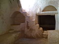 Inside view of a small dwelling
 -
 Old Town Rooftop View
 -
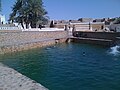 Old Town Spring Water Pool
 -
 Old Town Wall Entrance
 -
 Fruit Trees in the Old Town


See also
[edit]References
[edit]- ^ "Wolfram-Alpha: Making the world's knowledge computable". www.wolframalpha.com.
- ^ Der Spiegel Archived 6 October 2014 at the Wayback Machine, 2011 Aug 23
- ^ UNESCO World Heritage Centre. "Old Town of Ghadamès – UNESCO World Heritage Centre". Whc.unesco.org. Retrieved 26 May 2018.
- ^ Centre, UNESCO World Heritage. "Old Town of Ghadamès – UNESCO World Heritage Centre". whc.unesco.org. Retrieved 20 July 2016.
- ^ "World Meteorological Organization Climate Normals for 1991-2020 — Jalo". National Oceanic and Atmospheric Administration. Retrieved 13 June 2024.
- ^ "Klimatafel von Ghadames / Libyen" (PDF). Baseline climate means (1961–1990) from stations all over the world (in German). Deutscher Wetterdienst. Retrieved 27 March 2016.
- ^ "Appendix I: Meteorological Data" (PDF). Springer. Archived from the original (PDF) on 4 March 2016. Retrieved 27 March 2016.
- ^ a b "Ghadames (Ghudamis), Cydamus: the Pearl of The Libyan Sahara". Temehu.
- ^ Birley, Anthony R. Septimius Severus: The African Emperor. London: Routledge. (2000) [1971]. pg 147.
- ^ Saad, Elias N. (1983). Social History of Timbuktu: The Role of Muslim Scholars and Notables 1400–1900. Cambridge University Press. p. 8-9. ISBN 0-521-24603-2.
- ^ "The trans-Saharan slave trade - clues from interpolation analyses and high-resolution characterization of mitochondrial DNA lineages (Harich et al. 2010)". doi:10.1186/1471-2148-10-138. PMID 20459715.
{{cite web}}: Missing or empty|url=(help) - ^ K. S. McLachlan, "Tripoli and Tripolitania: Conflict and Cohesion during the Period of the Barbary Corsairs (1551–1850)", Transactions of the Institute of British Geographers, New Series, Vol. 3, No. 3, Settlement and Conflict in the Mediterranean World. (1978), pp. 285-294.
- ^ Libya: what about the south? The Guardian, 24 August 2011
- ^ "Libyan Tuaregs Flee to Algeria Amid Reports of Ethnic Cleansing". Archived from the original on 18 October 2017. Retrieved 17 October 2017.
- ^ Marozzi, Justin (18 September 2011). "Libyan Tuareg face reprisals". BBC News.
- ^ "Old Town of Ghadames (Libya) | African World Heritage Sites". africanworldheritagesites.org. Retrieved 8 March 2025.
- ^ whc.unesco.org https://whc.unesco.org/en/list/362/. Retrieved 8 March 2025.
{{cite web}}: Missing or empty|title=(help) - ^ UNDPAJNOPS, Project for the Rehabilitation of the Old City of Ghadames: Archtectural and Structural Survey of the Old City Buildings, Unpublished Report, Ghadames, Libya, pp. 7,2001.
- ^ Yoshaa, Q. B., Ghadames: Glimpses and Pictures, 1'' edition, AlFateh Press, Misurata, Libya, pp. 14-22, 197
- ^ a b Alkhalaf, Hiba; Elhabashi, Alaa; Hesham, Yassmen; Hiba, Abdulsalam; Omaar, Abdulkader; Walda, Hafed; Wootton, Will Thomas (1 January 2024). "Mapping attributes and managing heritage sites: the case of the Old Town of Ghadames-Libya". Journal of Cultural Heritage Management and Sustainable Development. ahead-of-print (ahead-of-print). doi:10.1108/JCHMSD-11-2023-0186. ISSN 2044-1266.
- ^ The World Heritage Newsletter, No.9, December 1995.
- ^ Centre, UNESCO World Heritage. "Libya's five World Heritage sites put on List of World Heritage in Danger". whc.unesco.org.
- ^ Alkhalaf, Hiba; Elhabashi, Alaa; Hesham, Yassmen; Hiba, Abdulsalam; Omaar, Abdulkader; Walda, Hafed; Wootton, Will Thomas (1 January 2024). "Mapping attributes and managing heritage sites: the case of the Old Town of Ghadames-Libya". Journal of Cultural Heritage Management and Sustainable Development. ahead-of-print (ahead-of-print). doi:10.1108/JCHMSD-11-2023-0186. ISSN 2044-1266.
Further reading
[edit]- Edmond Bernet (1912). "Ghadames". En Tripolitaine: Voyage a Ghadames (in French). Paris: Fontemoing.
- Lafi (Nora) "Ghadamès cité-oasis entre empire ottoman et colonisation"" in Federico Cresti (ed.), La Libia tra Mediterraneo e mondo islamico, Giuffrè, pp. 55–70, 2006
External links
[edit]- Falling Rain Genomics, Inc.: "Ghadamis, Libya"
- Azzouz, Intisar (1980) "Ghadames, Libya" In Safran, Linda (ed) (1980) Places of Public Gathering in Islam: proceedings of seminar five in the series Architectural transformations in the Islamic world, held in Amman, Jordan, 4–7 May Aga Khan Award for Architecture, Philadelphia, OCLC 7208199; photographs of Ghadames.
| Capital | ||
|---|---|---|
| Towns and villages | ||