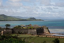
Fort Santa Isabel
| Fort Santa Isabel | |
|---|---|
| |
 | |
| Alternative names | Taytay Fort |
| General information | |
| Town or city | Taytay, Palawan |
| Country | Philippines |
| Coordinates | 10°49′41.9″N 119°31′3.9″E / 10.828306°N 119.517750°E |
| Named for | Isabella II of Spain |
| Completed |
|
| Renovated | 2018–2019 |
| Technical details | |
| Material | Coral limestone |
| Renovating team | |
| Architect(s) | Joel Rico |
Fort Santa Isabel (Filipino: Kutang Santa Isabel;[1] Spanish: Fuerza de Santa Isabel), also known as Taytay Fort, is a coastal fortification in the town of Taytay of Palawan, Philippines.
History
[edit]
Background
[edit]Fort Santa Isabel was originally built in 1667 as a wooden palisade under the Augustinian Recollect priests. It was named in honor of Isabella II of Spain.[2]
Through the efforts of Governor General Fernando Manuel de Bustillo,[1] the structure was replaced in 1738 by a coral limestone fort and was primarily used by the Spanish as a defensive structure against Muslim raiders.[2]
2018–2019 restoration
[edit]The municipal government of Taytay, with help from the National Historical Commission, commenced renovation works on the fort in 2018 as part of its Estrella del Norte Heritage Development Project. The project, led by heritage architect Joel Rico, was set to be finished by May 1, 2019.[2][needs update]
Gallery
[edit]References
[edit]- ^ a b Kutang Santa Isabel [Fort Santa Isabel] (Marker) (in Filipino). Fort Santa Isabel in Taytay, Palawan: National Historical Commission. 1993.
- ^ a b c Fabro, Keith Anthony (10 February 2018). "350-year-old Spanish fort in Palawan to undergo restoration". Rappler. Retrieved 10 May 2018.
External links
[edit] Media related to Fort Santa Isabel at Wikimedia Commons


