
File:WildfiresUS.pdf

Size of this JPG preview of this PDF file: 776 × 600 pixels. Other resolutions: 311 × 240 pixels | 621 × 480 pixels | 994 × 768 pixels | 1,280 × 989 pixels | 1,650 × 1,275 pixels.
Original file (1,650 × 1,275 pixels, file size: 5.34 MB, MIME type: application/pdf)
| This is a file from the Wikimedia Commons. Information from its description page there is shown below. Commons is a freely licensed media file repository. You can help. |
Summary
| Description |
English: Wildfires in the United States from 1980-2014 as depicted by fire weather zone (as defined by the National Weather Service). The map illustrates regional burdens for wildfires which mainly occur in the western and southern United States.
Nederlands: Natuurbranden in de Verenigde Staten 1980-2014, volgens brandweerzone (bepaald door de National Weather Service). De kaart illustreert de ongelijke regionale verdeling: vooral de westelijke en zuidelijke staten worden getroffen. |
| Date | |
| Source | Own work |
| Author | Lipson2 |
Licensing
I, the copyright holder of this work, hereby publish it under the following license:
This file is licensed under the Creative Commons Attribution-Share Alike 4.0 International license.
- You are free:
- to share – to copy, distribute and transmit the work
- to remix – to adapt the work
- Under the following conditions:
- attribution – You must give appropriate credit, provide a link to the license, and indicate if changes were made. You may do so in any reasonable manner, but not in any way that suggests the licensor endorses you or your use.
- share alike – If you remix, transform, or build upon the material, you must distribute your contributions under the same or compatible license as the original.
File history
Click on a date/time to view the file as it appeared at that time.
| Date/Time | Thumbnail | Dimensions | User | Comment | |
|---|---|---|---|---|---|
| current | 19:35, 8 December 2015 | 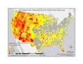 | 1,650 × 1,275 (5.34 MB) | Lipson2 | Cross-wiki upload from wiki.riteme.site |
File usage
The following pages on the English Wikipedia use this file (pages on other projects are not listed):
Global file usage
The following other wikis use this file:
- Usage on nl.wikipedia.org
- Usage on uk.wikipedia.org