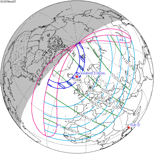
File:SE2015Mar20T.png
Appearance

Size of this preview: 599 × 600 pixels. Other resolutions: 240 × 240 pixels | 479 × 480 pixels | 728 × 729 pixels.
Original file (728 × 729 pixels, file size: 27 KB, MIME type: image/png)
File history
Click on a date/time to view the file as it appeared at that time.
| Date/Time | Thumbnail | Dimensions | User | Comment | |
|---|---|---|---|---|---|
| current | 18:22, 16 July 2015 |  | 728 × 729 (27 KB) | Cmdrjameson | Compressed with pngout. Reduced by 62kB (70% decrease). |
| 08:40, 9 August 2011 |  | 728 × 729 (89 KB) | OgreBot | (BOT): Reverting to most recent version; originally uploaded at en.wikipedia on 2009-12-08 20:37:41 by SockPuppetForTomruen | |
| 08:40, 9 August 2011 |  | 733 × 729 (89 KB) | OgreBot | (BOT): Uploading old version of file from en.wikipedia; originally uploaded on 2009-11-22 07:43:35 by Tomruen | |
| 10:13, 13 March 2011 |  | 728 × 729 (89 KB) | SamZane | {{Information |Description ={{en|1=Solar eclipse of march 20 2015 map.}} |Source =NASA |Author =NASA |Date = |Permission = |other_versions = }} Category:Solar eclipse map |
File usage
The following 74 pages use this file:
- List of solar eclipses in the 21st century
- List of solar eclipses visible from Israel
- List of solar eclipses visible from Ukraine
- March 2006 lunar eclipse
- March 2024 lunar eclipse
- Solar eclipse
- Solar eclipse of April 11, 2051
- Solar eclipse of April 19, 2004
- Solar eclipse of April 21, 2069
- Solar eclipse of April 30, 1957
- Solar eclipse of April 9, 1986
- Solar eclipse of August 11, 2018
- Solar eclipse of August 12, 2026
- Solar eclipse of August 12, 2045
- Solar eclipse of August 12, 2064
- Solar eclipse of August 13, 2083
- Solar eclipse of August 15, 2091
- Solar eclipse of August 21, 2017
- Solar eclipse of December 16, 2047
- Solar eclipse of December 22, 1870
- Solar eclipse of February 15, 1961
- Solar eclipse of February 15, 2018
- Solar eclipse of February 17, 2026
- Solar eclipse of February 26, 1979
- Solar eclipse of February 26, 2017
- Solar eclipse of February 28, 2044
- Solar eclipse of February 4, 1943
- Solar eclipse of February 7, 2073
- Solar eclipse of January 1, 1889
- Solar eclipse of January 14, 1907
- Solar eclipse of January 16, 2037
- Solar eclipse of January 24, 1925
- Solar eclipse of January 5, 2038
- Solar eclipse of January 5, 2057
- Solar eclipse of January 6, 2019
- Solar eclipse of January 6, 2076
- Solar eclipse of July 22, 1971
- Solar eclipse of June 1, 2011
- Solar eclipse of June 1, 2030
- Solar eclipse of June 1, 2087
- Solar eclipse of June 21, 1982
- Solar eclipse of March 19, 2072
- Solar eclipse of March 20, 2015
- Solar eclipse of March 20, 2034
- Solar eclipse of March 20, 2053
- Solar eclipse of March 30, 2033
- Solar eclipse of March 9, 1997
- Solar eclipse of March 9, 2016
- Solar eclipse of May 19, 1928
- Solar eclipse of May 2, 2087
- Solar eclipse of May 21, 1993
- Solar eclipse of May 31, 2049
- Solar eclipse of May 31, 2068
- Solar eclipse of November 16, 2058
- Solar eclipse of November 19, 1816
- Solar eclipse of October 15, 2069
- Solar eclipse of October 24, 2060
- Solar eclipse of October 24, 2079
- Solar eclipse of October 24, 2098
- Solar eclipse of October 25, 2022
- Solar eclipse of October 25, 2041
- Solar eclipse of September 1, 2016
- Solar eclipse of September 13, 2015
- Solar eclipse of September 13, 2080
- User:JPxG/sandbox98
- User:Kepler-1229b/sandbox/jul72195
- User:Tomruen/Project solar and lunar eclipses/SECharts
- Wikipedia:WikiProject Astronomy/Eclipses task force/SESetLists
- Wikipedia:WikiProject Astronomy/Eclipses task force/Work Page/SECharts
- Template:Solar Inex series 2015 March 20
- Template:Solar Metonic series 2011–2098
- Template:Solar Saros series 120
- Template:Solar Tritos series 2004 April 19
- Template:Solar eclipse set 2015–2018
Global file usage
The following other wikis use this file:
- Usage on ar.wikipedia.org
- كسوف الشمس 20 مارس 2015
- كسوف الشمس 1 يونيو 2011
- كسوف الشمس 1 سبتمبر 2016
- كسوف الشمس 26 فبراير 2017
- كسوف الشمس 25 أكتوبر 2022
- كسوف الشمس 12 أغسطس 2026
- كسوف الشمس 30 مارس 2033
- كسوف الشمس 5 يناير 2038
- كسوف الشمس 25 أكتوبر 2041
- كسوف الشمس 12 أغسطس 2045
- كسوف الشمس 31 مايو 2049
- كسوف الشمس 11 أبريل 2051
- كسوف الشمس 20 مارس 2034
- كسوف الشمس 20 مارس 2053
- كسوف الشمس 12 أغسطس 2064
- كسوف الشمس 5 يناير 2057
- كسوف الشمس 24 أكتوبر 2060
- كسوف الشمس 31 مايو 2068
- كسوف الشمس 21 أبريل 2069
- كسوف الشمس 6 يناير 2019
- كسوف الشمس 2 مايو 2087
- كسوف الشمس 1 يونيو 2087
- كسوف الشمس 19 مارس 2072
- كسوف الشمس 7 فبراير 2073
- كسوف الشمس 3 أغسطس 2073
- كسوف الشمس 27 يناير 2074
- كسوف الشمس 6 يناير 2076
- كسوف الشمس 24 أكتوبر 2079
- كسوف الشمس 21 مارس 2080
- كسوف الشمس 13 سبتمبر 2080
- كسوف الشمس 10 مارس 2081
- كسوف الشمس 13 أغسطس 2083
- كسوف الشمس 7 يناير 2084
- كسوف الشمس 3 يوليو 2084
- كسوف الشمس 27 ديسمبر 2084
- كسوف الشمس 22 يونيو 2085
- كسوف الشمس 16 ديسمبر 2085
- Usage on az.wikipedia.org
- Usage on be.wikipedia.org
- Usage on bg.wikipedia.org
- Usage on bn.wikipedia.org
- Usage on el.wikipedia.org
- Usage on es.wikipedia.org
- Usage on eu.wikipedia.org
View more global usage of this file.


