
File:Hawaii Brewing Corporation Limited in 1950 between Kapiolani and Kawaiahao, Sanborn Fire Insurance Map from Honolulu, Oahu County, Hawaii. LOC sanborn01537 006-38 (cropped).tif

Size of this JPG preview of this TIF file: 288 × 599 pixels. Other resolutions: 115 × 240 pixels | 231 × 480 pixels | 369 × 768 pixels | 492 × 1,024 pixels | 1,470 × 3,055 pixels.
Original file (1,470 × 3,055 pixels, file size: 12.85 MB, MIME type: image/tiff)
| This is a file from the Wikimedia Commons. Information from its description page there is shown below. Commons is a freely licensed media file repository. You can help. |
Summary
| Description |
English: Vol. 2, 1927 - Dec 1950. 117 Sheet(s). 002. Key map to edition. |
||
| Title | Sanborn Fire Insurance Map from Honolulu, Oahu County, Hawaii. | ||
| Shelf ID | https://www.loc.gov/item/sanborn01537_006/ | ||
| Parent | https://www.loc.gov/resource/g4384hm.g01537195002/ | ||
| Sheet title | Image 38 of Sanborn Fire Insurance Map from Honolulu, Oahu County, Hawaii. | ||
| Date | |||
| Source | https://www.loc.gov/item/sanborn01537_006/ | ||
| Author | Unknown author | ||
| Permission (Reusing this file) |
|
||
| Other versions |
|
||
| Location | Oahu County · Hawaii · Honolulu | ||
| Part of | American Memory · Sanborn Maps · Geography And Maps Division · Sanborn Fire Insurance Maps |


Licensing
This work is in the public domain in the United States because it is a work prepared by an officer or employee of the United States Government as part of that person’s official duties under the terms of Title 17, Chapter 1, Section 105 of the US Code.
Note: This only applies to original works of the Federal Government and not to the work of any individual U.S. state, territory, commonwealth, county, municipality, or any other subdivision. This template also does not apply to postage stamp designs published by the United States Postal Service since 1978. (See § 313.6(C)(1) of Compendium of U.S. Copyright Office Practices). It also does not apply to certain US coins; see The US Mint Terms of Use.
|
 | |
| This file has been identified as being free of known restrictions under copyright law, including all related and neighboring rights. | ||
File history
Click on a date/time to view the file as it appeared at that time.
| Date/Time | Thumbnail | Dimensions | User | Comment | |
|---|---|---|---|---|---|
| current | 02:39, 14 July 2020 | 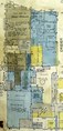 | 1,470 × 3,055 (12.85 MB) | Tibet Nation | File:Sanborn Fire Insurance Map from Honolulu, Oahu County, Hawaii. LOC sanborn01537 006-38.tif cropped 77 % horizontally, 60 % vertically using CropTool with precise mode. |
File usage
The following pages on the English Wikipedia use this file (pages on other projects are not listed):