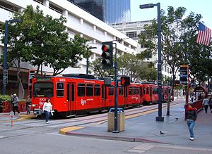
Fifth Avenue station (San Diego)
Fifth Avenue | |||||||||||||||||||||
|---|---|---|---|---|---|---|---|---|---|---|---|---|---|---|---|---|---|---|---|---|---|
 Orange Line trolley at Fifth Avenue | |||||||||||||||||||||
| General information | |||||||||||||||||||||
| Location | 500 C Street San Diego, California United States | ||||||||||||||||||||
| Coordinates | 32°43′00″N 117°09′36″W / 32.716749°N 117.160051°W | ||||||||||||||||||||
| Owned by | San Diego Metropolitan Transit System | ||||||||||||||||||||
| Operated by | San Diego Trolley | ||||||||||||||||||||
| Platforms | 2 side platforms | ||||||||||||||||||||
| Tracks | 2 | ||||||||||||||||||||
| Connections | |||||||||||||||||||||
| Construction | |||||||||||||||||||||
| Structure type | At-grade | ||||||||||||||||||||
| Accessible | |||||||||||||||||||||
| Other information | |||||||||||||||||||||
| Station code | 75088, 75089[2] | ||||||||||||||||||||
| History | |||||||||||||||||||||
| Opened | July 26, 1981[3] | ||||||||||||||||||||
| Rebuilt | 2013[4] | ||||||||||||||||||||
| Previous names | Gaslamp (1981–1990) | ||||||||||||||||||||
| Services | |||||||||||||||||||||
| |||||||||||||||||||||
| |||||||||||||||||||||
Fifth Avenue station (formerly Gaslamp station) is a station of the Orange Line, Blue Line, and Silver Line on the San Diego Trolley. It is located in the Core district of downtown San Diego, California. The station is located along on C Street, between Sixth Avenue and its namesake Fifth Avenue, surrounded by several office buildings.
It is one of the original stations of the San Diego Trolley, opening on July 26, 1981. At the time of opening, it was called Gaslamp station, due to its proximity to the Gaslamp Quarter.[5] During the development of the Bayside extension, which would include a station much closer to the Gaslamp Quarter, this station was often called Gaslamp North station, while the new station was called Gaslamp South.[6] When the Bayside extension opened in 1990, the new stop was called Gaslamp Quarter station, and this station was renamed Fifth Avenue to avoid confusion.
This station was closed between December 17, 2012[7] and June 2013[4] for renovations as part of the Trolley Renewal Project.[8]
Station layout
[edit]There are two tracks, each with a side platform.
| Side platform, doors will open on the right | |
| Northbound/ Westbound |
← ← |
| Southbound/ Eastbound |
|
| Side platform, doors will open on the right | |
References
[edit]- ^ "San Diego Regional Transit Map" (PDF). San Diego Metropolitan Transit System. October 2023. Retrieved June 11, 2024.
- ^ "Schedules & Real Time". San Diego Metropolitan Transit System. Retrieved April 9, 2020.
- ^ "History". San Diego Metropolitan Transit System. May 22, 2015. Retrieved April 9, 2020.
- ^ a b "MTS Downtown San Diego & Blue Line Station Construction Advisory for June 4, 2013" (PDF). San Diego Metropolitan Transit System. June 4, 2013. Archived from the original (PDF) on December 31, 2013. Retrieved December 29, 2013.
- ^ "1988 Trolley Timetable". March 31, 2011. Retrieved April 16, 2021.
- ^ "MTDB Trolley Map, 1980s". April 7, 2013. Retrieved April 16, 2021.
- ^ "5th Avenue Trolley Station to Close for Three Months". San Diego Metropolitan Transit System. December 13, 2012. Retrieved December 29, 2013.
- ^ "Trolley Renewal Project". San Diego Metropolitan Transit System. 2013. Retrieved December 29, 2013.

