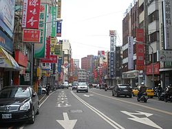
Fengyuan District
Fengyuan
豐原區 | |
|---|---|
| Fengyuan District | |
 | |
 | |
| Coordinates: 24°15′N 120°43′E / 24.250°N 120.717°E | |
| Country | Republic of China (Taiwan) |
| Special municipality | Taichung |
| Area | |
• Total | 41.1845 km2 (15.9014 sq mi) |
| Population (February 2023) | |
• Total | 163,750 |
| • Density | 4,031/km2 (10,440/sq mi) |
| Time zone | UTC+8 (National Standard Time) |
| Postal code | 420 |
| Website | www |
| Fengyuan District | |||||||||||||
|---|---|---|---|---|---|---|---|---|---|---|---|---|---|
| Traditional Chinese | 豐原區 | ||||||||||||
| |||||||||||||
| Alternative Chinese name | |||||||||||||
| Traditional Chinese | 葫蘆墩 | ||||||||||||
| |||||||||||||

Fengyuan District (Chinese: 豐原區) is a district located in north-central Taichung, Taiwan on the south bank of the Dajia River. Fengyuan district is the third most populated district among former Taichung County, ranking after Dali and Taiping district. Fengyuan was recognized as Huludun in early times, meaning "gourd" in Chinese, for a gourd-shape pile of mud that was found in Fengyuan by the aborigines. The rice produced in Fengyuan is famous for its high quality and the bakery industry prospered in later decades. Because of its location of the intersection of Taiwan Railways Administration Western Trunk line and Dongshi branch line, Fengyuan quickly expanded after World War II. It soon became one of the regions with great economic and cultural development in central Taiwan. After the merger of Taichung City and Taichung County in 2010, population and economic growth slowed slightly. so recently, fengyuan faces the challenge of being marginalized .
History
[edit]Before the arrival of the Han Chinese, the area of that is now Fengyuan was inhabited by Taiwanese aborigines. Their name for the area, meaning "thriving pine forest", was transcribed into Chinese characters as 泰耶爾墩. Before the mid-18th century, the area was a territory of the Pazeh people, which they called Haluton. This name was adapted into Hokkien as Haloton (Chinese: 葫蘆墩; Pe̍h-ōe-jī: Hô͘-lô͘-tun; lit. 'gourd mound').
Han immigration to the area began during late Qing rule. Liu Mingchuan gave the area a nickname of "little Suzhou" due to its prosperity and scenic beauty.
Empire of Japan
[edit]In 1905, during Japanese rule, the Holotun Station was erected, putting the area along a main thoroughfare. In 1920, the Governor-General of Taiwan gave the town its name, Toyohara (Japanese: 豐原), meaning flourishing plain. Emperor Meiji, Emperor Taishō, and Emperor Hirohito ate rice supplied from Toyohara until 1953.
After World War II
[edit]After World War II in 1945, the area was renamed to Fengyuan and was organized as an urban township of Taichung County. In 1950, it was made the capital of the county from the former capital Yuanlin after the separation of Changhua County and Nantou County from Taichung County. On 1 March 1976, Fengyuan was upgraded to a county-administered city due to its population. On 25 December 2010, Taichung County was merged with Taichung City and Fengyuan was upgraded to a district of the city with Xitun District as the capital of the city.
The restaurant chain KLG has its headquarters in Fengyuan District.[1] In the 1970s, citizens created the Miaodong Night Market (廟東夜市), that is full of Taiwanese street foods.
The district is also home to the Fengyuan Museum of Lacquer Art and the Taichung Municipal City Huludun Cultural Center.
Transportation
[edit]Rail
[edit]
Fengyuan District is accessible from TRA Fengyuan Station.
Road
[edit]
Notable natives
[edit]- Chang Yu-sheng, pop singer
- Johnny Chiang, Chairperson of Kuomintang
- Kuan Bi-ling, member of Legislative Yuan (2008–2020)
- Lin Chung-chiu, baseball player
- Liu Fu-hao, baseball player
- Tu Ai-yu, golfer
- Winnie Hsin, pop singer
References
[edit]- ^ ""Contact Us". KLG. Retrieved March 7, 2016.
快樂雞股份有限公司 台中市豐原區西勢路154號
External links
[edit]- Official website
 (in Chinese)
