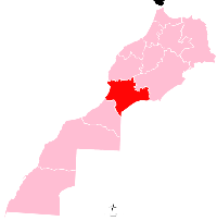
Fam El Hisn
Appearance
Fam El Hisn
Imi Ugadir Imi-n-Ugadir | |
|---|---|
Town | |
 | |
| Country | |
| Region | Souss-Massa |
| Province | Tata Province |
| Population (2004) | |
• Total | 7,089 |
| Time zone | UTC+0 (WET) |
| • Summer (DST) | UTC+1 (WEST) |
Fam El Hisn is a town in Tata Province, Souss-Massa, Morocco. According to a 2004 census, it had a population of 7,089.[1]
External links
[edit]Wikivoyage has a travel guide for Fam El Hisn.
References
[edit]29°01′08″N 8°53′28″W / 29.01889°N 8.89111°W

