Ernan Castle
Tools
Actions
General
Print/export
In other projects
Appearance
From Wikipedia, the free encyclopedia
Castle in Yazd Province, Iran
| Ernan castle | |
|---|---|
قلعه ارنان | |
 | |
 | |
| General information | |
| Type | Castle |
| Town or city | Mehriz County |
| Country | |
| Coordinates | 31°19′04″N 54°09′22″E / 31.3178°N 54.1561°E / 31.3178; 54.1561 |
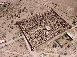
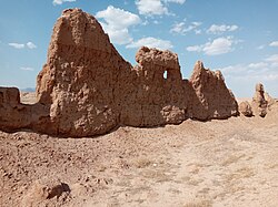
Ernan castle (Persian: قلعه ارنان) is a historical castle located in Mehriz County in Yazd Province, The longevity of this fortress dates back to the Qajar dynasty.[1][2]
References
[edit]- ^ "قلعه قاجاری ارنان در مهریز یزد ثبت ملی شد". Iranian Students News Agency. Retrieved 13 February 2021.
- ^ "قلعه تاريخي ارنان مهريز ثبت ملي شد". Islamic Republic News Agency. Retrieved 13 February 2021.
This article about a castle in Iran is a stub. You can help Wikipedia by expanding it. |


