Elephant Spit


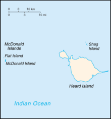
Elephant Spit is a 9 km long sand spit at the eastern end of subantarctic Heard Island, in the Australian territory of Heard Island and McDonald Islands, lying in the Southern Ocean on the Kerguelen Plateau about 450 km south-east of the Kerguelen Islands. The name refers to southern elephant seals, also known as sea elephants, which breed in large numbers on Heard Island and formed the basis for commercial sealing for oil there during the 19th century.
Description
[edit]Elephant Spit is long, thin, straight and conspicuous, giving the island a distinctive shape as seen from space. It borders Spit Bay to the north and west, and is formed of sediments derived from the glacial erosion of volcanic material from eruptions by Big Ben, which have made the seabed south-east of the island relatively shallow.[1]
Heard Island is isolated, uninhabited, and rarely visited. When the island was visited in 2002 and 2003 by scientists from the Australian Antarctic Division, the spit was intact. However, a following visit in late 2008 found that a section of the eastern end of the spit had become inundated by the ocean, forming a 2-km-long island.[2]
References
[edit]- ^ "Geomorphology: Why Heard Island looks like it does..." Department of Sustainability, Environment, Water, Population and Communities, Australia. Retrieved 2011-02-23.
- ^ "Rare visit to remote Southern Ocean territory finds changes". Department of Sustainability, Environment, Water, Population and Communities, Australia. 2009-01-15. Archived from the original on 2011-03-16. Retrieved 2011-02-23.
External links
[edit]53°5′S 73°48′E / 53.083°S 73.800°E
