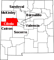
El Rito, Cibola County, New Mexico
Appearance
El Rito, New Mexico | |
|---|---|
| Coordinates: 34°59′57″N 107°18′00″W / 34.99917°N 107.30000°W | |
| Country | United States |
| State | New Mexico |
| County | Cibola |
| Elevation | 5,656 ft (1,724 m) |
| Time zone | UTC-7 (Mountain (MST)) |
| • Summer (DST) | UTC-6 (MDT) |
| Area code | 505 |
| GNIS feature ID | 898769[1] |
El Rito is an unincorporated community in Cibola County, New Mexico, United States.[1] El Rito is located approximately two miles southeast of Mesita on the Laguna Reservation. It is located on the north bank of the Rio San Jose and was named after the creek.[2]
Notes
[edit]- ^ a b "El Rito, Cibola County, New Mexico". Geographic Names Information System. United States Geological Survey, United States Department of the Interior.
- ^ Julyan, Robert (1996). The Place Names of New Mexico. University of New Mexico Press. p. 120. ISBN 0826316891.


