Echtenerbrug
Appearance
Echtenerbrug
Ychtenbrêge | |
|---|---|
Village | |
 | |
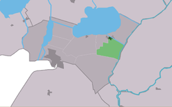
 Location in the former Lemsterlân municipality | |
| Coordinates: 52°52′16″N 5°49′16″E / 52.87111°N 5.82111°E | |
| Country | |
| Province | |
| Municipality | |
| Area | |
• Total | 6.61 km2 (2.55 sq mi) |
| Elevation | −0.3 m (−1.0 ft) |
| Population (2021)[1] | |
• Total | 1,005 |
| • Density | 150/km2 (390/sq mi) |
| Postal code | 8539[1] |
| Dialing code | 0514 |
Echtenerbrug (West Frisian: Ychtenbrêge) is a small village in De Fryske Marren in the province of Friesland, the Netherlands. It has a population of around 1035 including surrounding area.[3]
The villages of Delfstrahuizen and Echtenerbrug are separated by a canal.[4]
History
[edit]The village was first mentioned in 1718 as Echterbrug, and means bridge near Echten.[5] Echtenerbrug is a road village which developed in the Middle Ages to the east of Echten.[6]
Gallery
[edit]-
House in Echtenerbrug
-
Street view
-
Looking towards Tjeukemeer
-
House in Echtenerbrug
References
[edit]- ^ a b c "Kerncijfers wijken en buurten 2021". Central Bureau of Statistics. Retrieved 29 March 2022.
- ^ "Postcodetool for 8539RM". Actueel Hoogtebestand Nederland (in Dutch). Het Waterschapshuis. Retrieved 29 March 2022.
- ^ Kerncijfers wijken en buurten 2017 - CBS
- ^ "Delfstrahuizen". Plaatsengids (in Dutch). Retrieved 29 March 2022.
- ^ "Echtenerbrug - (geografische naam)". Etymologiebank (in Dutch). Retrieved 29 March 2022.
- ^ Ronald Stenvert & Sabine Broekhoven (2000). "Echten" (in Dutch). Zwolle: Waanders. ISBN 90 400 9476 4. Retrieved 29 March 2022.
External links
[edit]![]() Media related to Echtenerbrug at Wikimedia Commons
Media related to Echtenerbrug at Wikimedia Commons


![Looking towards Tjeukemeer [nl]](http://upload.wikimedia.org/wikipedia/commons/thumb/9/96/Echtenerbrug_met_Pier_Christiaansloot_en_Tjeukemeer.jpg/120px-Echtenerbrug_met_Pier_Christiaansloot_en_Tjeukemeer.jpg)
