Dora Baltea
| Dora Baltea Doire Baltée | |
|---|---|
 The river near Sarriod de la Tour Castle | |
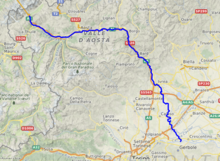
 Dora Baltea location | |
| Native name |
|
| Location | |
| Country | Italy |
| Physical characteristics | |
| Source | |
| • location | Entrèves near Courmayeur |
| • elevation | 1,400 m (4,600 ft) |
| Mouth | |
• location | Po near Crescentino |
• coordinates | 45°10′49″N 8°02′52″E / 45.1804°N 8.0477°E |
| Length | 168.3 km (105 mi)[1] |
| Basin size | 3,890.52 km2 (1,502 sq mi)[2] |
| Discharge | |
| • average | (mouth) 96.0 m3/s (3,390 cu ft/s)[2] |
| Basin features | |
| Progression | Po→ Adriatic Sea |
| Tributaries | |
| • left | Buthier, Saint-Barthélemy, Marmore, Évançon, Lys |
| • right | Doire de Verney, Savara, Grand'Eyvia, Chalamy, Ayasse, Chiusella |

Dora Baltea (Italian: [ˈdɔːra ˈbaltea]) or Doire Baltée (French: [dwaʁ balte]) is a river in northwestern Italy. It is a left-hand tributary of the Po and is about 170 kilometres (110 mi) long.
Name
[edit]The river's Latin name was Duria maior, Duria Baltica or Duria Bautica.[3][4][5] Strabo called it Δουριας (Dourias) in Greek.[6] The name "Duria" is from the Celtic root *dubr- ("flow"), found in many European river names such as Douro / Duero; it derives from Proto-Indo-European *dʰew- ("flow").[7] The second part may derive from the Illyrian root *balta ("‘swamp, marsh, white clay").[8][9][10]
In the local languages, the river is called Arpitan: Duère Baltèa, Valdôtain: Djouiye;[11] Piedmontese: Deura Bàotia.
Geography
[edit]It originates by Mont Blanc as the confluence of the Dora di Ferret, fed by the Pré de Bar Glacier in Val Ferret, and the Dora di Veny, fed by the Miage Glacier and Brenva Glacier in Val Veny.
As it crosses the Aosta Valley, the Dora Baltea flows through the city of Aosta (where the Buthier runs into it) and near all the main cities of the lower Aosta Valley: Châtillon, Saint-Vincent, Verrès and Pont-Saint-Martin. After it enters Piedmont, it passes through the city of Ivrea and a good part of Canavese, gets from its right hand the waters of the Chiusella and reaches the Po at Crescentino, a little downstream from Chivasso.
Water uses
[edit]It is a popular place for whitewater rafting and kayaking. Early in the summer, in May and June, the rivers are usually high with snow melt from the mountains. During July, August and September the water levels are usually lower and the temperature warmer.
See also
[edit]- The Dora Riparia is another tributary of the Po.
References
[edit]- ^ AA.VV. (2004). "Elaborato I.c/5". Piano di Tutela delle Acque - Revisione del 1º luglio 2004; Caratterizzazione bacini Idrografici (PDF). Regione Piemonte. Archived from the original (PDF) on 2012-02-25. Retrieved 2012-06-10.
- ^ a b AA.VV. (2004). "Elaborato I.c/7". Piano di Tutela delle Acque - Revisione del 1º luglio 2004; Caratterizzazione bacini Idrografici (PDF). Regione Piemonte. Archived from the original (PDF) on 2012-02-25. Retrieved 2012-06-10.
- ^ Smith, William (May 3, 1878). "A Dictionary of Greek and Roman Geography: Abacaenum-Hytanis". J. Murray – via Google Books.
- ^ "Dictionary of Greek and Roman Geography (1854), DU´RIA". Perseus.tufts.edu.
- ^ Dòra Bàltea (in Italian).
{{cite encyclopedia}}:|website=ignored (help) - ^ "Dictionnaire de géographie ancienne et moderne à l'usage du libraire et de l'amateur de livres". May 3, 1870 – via Google Books.
- ^ Forbiger, Albert (May 3, 1848). "Handbuch Der Alten Geographie". Mayer und Wigand – via Google Books.
- ^ "Archived copy" (PDF). Archived from the original (PDF) on 2020-12-09. Retrieved 2021-05-03.
{{cite web}}: CS1 maint: archived copy as title (link) - ^ "Indo-European Etymological Dictionary". Academiaprisca.org. Retrieved 24 January 2022.
- ^ Pietro U. Dini (2014). "Foundations of Baltic Languages" (PDF). Esparama.lt. Retrieved 24 January 2022.
- ^ Djouiye - Site web du francoprovençal valdôtain.
