
Châtillon, Aosta Valley
Châtillon | |
|---|---|
| Comune di Châtillon Commune de Châtillon | |
 | |
 Coat of arms | |
Location of Châtillon  | |
 Châtillon Location of Châtillon in Italy  Châtillon Châtillon (Aosta Valley) | |
| Coordinates: 45°44′56″N 07°36′52″E / 45.74889°N 7.61444°E | |
| Country | Italy |
| Region | Aosta Valley |
| Province | none |
| Frazioni | see list |
| Area | |
• Total | 39.77 km2 (15.36 sq mi) |
| Elevation | 549 m (1,801 ft) |
| Population (31 December 2022)[2] | |
• Total | 4,358 |
| • Density | 110/km2 (280/sq mi) |
| Demonym | Châtillonnais |
| Time zone | UTC+1 (CET) |
| • Summer (DST) | UTC+2 (CEST) |
| Postal code | 11024 |
| Dialing code | 0177 |
| Patron saint | St. Peter |
| Saint day | June 29 |
| Website | Official website |
Châtillon (French: [ʃatijɔ̃] ⓘ; Valdôtain: Tschahtéyón; Issime Walser: Géschtullju); is a town and comune in the Aosta Valley region of northwestern Italy.
Toponym
[edit]Châtillon was renamed "Castiglion Dora" in Italian in 1939 during Fascist rule in Italy. It was reverted to its original name in 1946.
Notable people
[edit]Châtillon is the ancestral home of the Bich family, whose most famous member was Marcel Bich, founder of Société Bic.
-
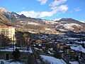 Winter panorama of Châtillon.
 -
 The church of Notre-Dame-de-Grâces.


Albard, Bellecombe, Breil-de-Barrel (or Petit-Breil), Gros-Breil, Bourg, Brusoncles, Brusoncles-des-Gard (or Brusoncles-Dessus), Brusoncles-des-Janin (or Brusoncles-Dessous), Barme-des-Antesans, Cret-de-Breil, Grange-de-Barme, Chaméran, Champlong, Fours, Ventoux, Garin, Sez-de-Val, La Fournaise, Conoz, La Verdettaz, Murate, Isseuries, Perrianaz, Chardin, Promiod, Boëttes, Francou, Arsine, Brenvey, Chancellier, Revard, Bioure, Salère, Varé, Chenez, Pointé, Étavé, Chésalet, Toniquet, Assert, Fressoney, Nissod, Travod, Domianaz, Closel, La Tour, Verlex, La Sounère, Barmusse, Crétadonaz, Cret-Blanc, Chavod, Merlin, Tour-de-Grange, Sarmasse, Barmafol, Plantin, Perolles, Soleil, Bretton, Saint-Valentin, Sellotaz, Govergnou, Cillod, Panorama, Remela, Neran, Larianaz, Gléréyaz, La Marca, Crétaz, Cloîtres, Plan-Pissin, Tornafol, Saint-Clair, Piou, Cérouic, Étrop, Pragarin, Salé, Les Îles, Les Pérolles, Taxard, Ussel, Château-d'Ussel, Biolasse, Perry, Mont Ross, Toule.
References
[edit]- ^ "Superficie di Comuni Province e Regioni italiane al 9 ottobre 2011". Italian National Institute of Statistics. Retrieved 16 March 2019.
- ^ "Popolazione Residente al 1° Gennaio 2018". Italian National Institute of Statistics. Retrieved 16 March 2019.

| International | |
|---|---|
| National | |
This article on a location in Aosta Valley is a stub. You can help Wikipedia by expanding it. |