
Draft:Cottessergroeve
| Draft article not currently submitted for review.
This is a draft Articles for creation (AfC) submission. It is not currently pending review. While there are no deadlines, abandoned drafts may be deleted after six months. To edit the draft click on the "Edit" tab at the top of the window. To be accepted, a draft should:
It is strongly discouraged to write about yourself, your business or employer. If you do so, you must declare it. Where to get help
How to improve a draft
You can also browse Wikipedia:Featured articles and Wikipedia:Good articles to find examples of Wikipedia's best writing on topics similar to your proposed article. Improving your odds of a speedy review To improve your odds of a faster review, tag your draft with relevant WikiProject tags using the button below. This will let reviewers know a new draft has been submitted in their area of interest. For instance, if you wrote about a female astronomer, you would want to add the Biography, Astronomy, and Women scientists tags. Editor resources
Last edited by Dclemens1971 (talk | contribs) 4 months ago. (Update) |
.jpg)
.jpg)
.jpg)
The Cottessergroeve, also known as the Quartzite Quarry or Groeve Wijkerslooth[1] is a quarry and geological monument located in South Limburg, Netherlands, in the municipality of Vaals. The quarry is situated southeast of Epen and southwest of Cottessen along a steep cliff by the Geul River in the Geuldal valley, at the base of the southwestern slope of the Plateau van Vijlen.
The site is a nature reserve and geological monument owned by Staatsbosbeheer (State Forestry Service) and is open to the public.
History
[edit]The quarry initially extracted quartzite, a type of rock that was broken and screened near the quarry before being supplied to Chamotte Unie in Geldermalsen for the production of fire-resistant bricks known as "Dinas stones" (fire-resistant and silica-containing).[2]
From the 1940s until 1957, underground mining also took place, creating a mine shaft. The extracted material was used to produce fire-resistant furnace linings.[3] Later werden meer tunnels geboord en de oude gangen werden met steenafval gevuld.[2] In 1960 werd de winning gestaakt.[4] Later, more tunnels were drilled, and the old shafts were filled with stone waste. Mining ceased in 1960.
Geology
[edit]South of Epen, older rocks from the Epen Formation, approximately 330 million years old from the Upper Carboniferous (Namurian), are exposed alongside the Limburgian Chalk. The Cottessergroeve features a thick layer of quartzite at the surface. These quartzitic sandstones and shales are folded in the subsurface and have a steep southern inclination. The rock has large cleavages, which allowed for easy extraction and widespread use as building material.[3][5]
Above the quartzite layer are fine-layered shales, which contain fossils, though the specimens found were poorly preserved.[3]
The mountain formation at the end of the Carboniferous period in the Ardennes and Eifel also affected South Limburg, leading to the deposition of dissolved silica between sand grains, creating a hard quartzite bank. This period also involved folding and faulting, resulting in notable fractures in the quartzite bank, known as diaclases.[3]
In the quarry wall, an anticline structure is visible, disturbed by two faults, causing the thick quartzite bank to shift.[3]
Usage
[edit]Stones from the Cottessergroeve were used in the construction of the nearby Hoeve Termoere.[6]
-
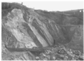 The quartzite quarry at Cottessen around 1950
 -
 Cleavage planes indicated (1947)
 -
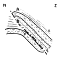 Diagram of the Cottessergroeve


50°45′31.46″N 5°56′16.59″E / 50.7587389°N 5.9379417°E
References
[edit]- ^ Kwartsiet, zandsteen en leisteen, P.J. Felder, Grondboor en Hamer, jaargang 43, nummer 5/6, p. 137-140, november 1989. Gearchiveerd op 2 december 2022.
- ^ a b De Cottessergroeve in het Geuldal. Gearchiveerd op 9 december 2022.
- ^ a b c d e Geologische monumenten in Zuid-Limburg (cd-rom), P.W. Bosch, W.M. Felder, Netherlands Organisation for Applied Scientific Research, 1999
- ^ Carboongroeves bij Cottessen in Zuid-Limburg, Grondboor & Hamer, nr 5, 2007. Gearchiveerd op 2 juli 2022.
- ^ Voorkomen en gebruik van natuurlijke bouwsteen in Limburg, P.W. Bosch, Grondboor & Hamer, 1989. Gearchiveerd op 2 december 2022.
- ^ Hoeve Termoere. Gearchiveerd op 24 maart 2023.