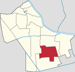
Donghai Subdistrict, Tianjin
Appearance
Donghai Subdistrict
东海街道 | |
|---|---|
 Location within Hexi District | |
| Coordinates: 39°03′25″N 117°15′01″E / 39.05694°N 117.25028°E | |
| Country | China |
| Municipality | Tianjin |
| District | Hexi |
| Village-level Divisions | 12 communities |
| Area | |
• Total | 2.12 km2 (0.82 sq mi) |
| Elevation | 4 m (13 ft) |
| Population (2010) | |
• Total | 80,013 |
| • Density | 38,000/km2 (98,000/sq mi) |
| Time zone | UTC+8 (China Standard) |
| Postal code | 300223 |
| Area code | 022 |
Donghai Subdistrict (simplified Chinese: 东海街道; traditional Chinese: 東海街道; pinyin: Dōnghǎi Jiēdào) is a subdistrict in the southeast corner of Hexi District, Tianjin, China. It shares border with Chentangzhuang Subdistrict in the north and east, Taihu Road Subdistrict in the south, and Jianshan Subdistrict in the west. Its population was 80,013 as of the 2020 census.[1]
The subdistrict's name Donghai literally means "East Sea".[2]
History
[edit]| Year | Status | Belong to |
|---|---|---|
| 1981 - 1992 | Zhujiangdao Subdistrict | Hexi District, Tianjin |
| 1992 - 1994 | Zhujiangdao Subdistrict
Sanshuidao Subdistrict | |
| 1994 - present | Donghai Subdistrict |
Administrative divisions
[edit]In 2021, Donghai Subdistrict was divided into 12 residential communities. They are listed as follows:[3]
| Subdivision Names | Name Transliterations |
|---|---|
| 云江新苑 | Yunjiang Xinyuan |
| 兰江新苑 | Lanjiang Xinyuan |
| 龙江里 | Longjiangli |
| 川江里 | Chuanjiangli |
| 华江里第一 | Huajiangli Diyi |
| 华江里第二 | Huajiangli Di'er |
| 松江里 | Songjangli |
| 粤江里 | Yuejiangli |
| 桂江里 | Guijiangli |
| 三水南里 | Sanshui Nanli |
| 汉江里 | Hanjiangli |
| 儒林园 | Rulinyuan |
References
[edit]- ^ "China: Tiānjīn Municipal Province (Districts and Townships) - Population Statistics, Charts and Map". www.citypopulation.de. Retrieved 2022-11-05.
- ^ a b 中华人民共和国政区大典:天津市卷 (in Chinese). 中国社会出版社. 2020.
- ^ "2021年统计用区划代码和城乡划分代码". www.stats.gov.cn. Retrieved 2022-11-09.


