Devil Mountain Lakes


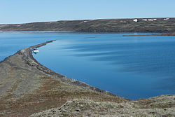
Devil Mountain Lakes (Inupiaq: Qitiqłiik[1]) is a maar (a form of crater lake) in the western part of Alaska. The lake is considered to be the largest maar in the world[2] and is part of the Espenberg volcanic field.
Geography
[edit]Devil Mountain Lakes is located about 100 km (62 mi) southwest of Kotzebue on the northern part of the Seward Peninsula.[3] The coordinates are 66°23′41″N 164°29′18″W / 66.39472°N 164.48833°W.
The crater lake has a diameter of about 8 kilometers (5.0 mi) and is part of the Bering Land Bridge National Preserve. It consists of two connected craters, [2] North Devil Mountain Lake with a diameter of about 5.1 km (3.2 mi) and South Devil Mountain Lake with a diameter of about 3.4 km (2.1 mi).[4]
There are several nearby maars, such as the Killeak Lakes (North Killeak maar and South Killeak maar) and White Fish Lake (Whitefish Maar). The area is sometimes also called Espenberg Maars.[4]
History
[edit]The lake was probably shaped during volcanic eruptions about 21,000 years ago during the Pleistocene Ice Age as lava flows came through the permafrost creating violent underground explosions.[2]
On December 1, 1978 the nature reserve was established as "Bering Land Bridge National Monument" changing the name on December 2, 1980 to "Bering Land Bridge National Preserve".
See also
[edit]References
[edit]- ^ "What's in a Name?:Rekindling Traditional Inupiat Place Names (U.S. National Park Service)".
- ^ a b c [1] Archived 2008-09-26 at the Wayback Machine, Alaska Science Forum
- ^ [2], WikiMapia
- ^ a b [3] Archived 2017-03-11 at the Wayback Machine, Arctic 1996, vol 49, nr 1
External links
[edit]- About Devil Mountain Lakes [permanent dead link] - University of Alaska System
- Map of Devil Mountain Lakes - University of Texas
- Devil Mountain Lakes - National Park Service
