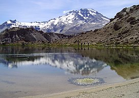
Descabezado Grande
| Descabezado Grande | |
|---|---|
 | |
| Highest point | |
| Elevation | 3,953 m (12,969 ft) |
| Coordinates | 35°35′26″S 70°44′48″W / 35.59056°S 70.74667°W |
| Geography | |
| Location | Central Chile |
| Parent range | Andes |
| Geology | |
| Rock age | Pleistocene |
| Mountain type | Stratovolcano |
| Volcanic arc/belt | South Volcanic Zone |
| Last eruption | June 1933 |
Descabezado Grande (also Cerro Azul or Quizapu[1]) is a stratovolcano located in the Maule Region of central Chile. It is capped by a 1.4-kilometre-wide (0.9 mi) ice-filled caldera and named for its flat-topped form, as descabezado means "headless" in Spanish. A smaller crater about 500 metres (1,600 ft) wide is found in the northeast part of the caldera, and it has active fumaroles.
The volcano is composed of andesite and rhyodacite lava flows along with pyroclastic flow deposits. It has a basal diameter of about 10 by 12 kilometres (6.2 by 7.5 mi) and a total volume of about 30 cubic kilometres (7.2 cu mi). Along with Cerro Azul, 7 kilometres (4.3 mi) to the south, it lies at the center of a 20-by-30-kilometre (12-by-19-mile) volcanic field.
Gallery
[edit]-
Descabezado Grande volcano from the air. View to the east.
-
Descabezado Grande is in the top center of this NASA World Wind screenshot.
See also
[edit]References
[edit]- ^ Webpage OVDAS Archived 2013-10-29 at the Wayback Machine, about Descabezado Grande, retrieved on 28 October 2013
- "Descabezado Grande". Global Volcanism Program. Smithsonian Institution.
- González-Ferrán, Oscar (1995). Volcanes de Chile. Santiago, Chile: Instituto Geográfico Militar. p. 640 pp. ISBN 956-202-054-1. (in Spanish; also includes volcanoes of Argentina, Bolivia, and Peru)
- Biggar, John (2005). The Andes: A Guide for Climbers (3rd ed.). Andes Publishing (Scotland). p. 304 pp. ISBN 0-9536087-2-7.


