Damongo
Damongo
Demanwu | |
|---|---|
Regional Capital | |
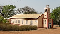
 St Anne's Catholic Cathedral | |
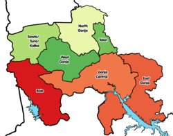
Location of Damongo in Savannah region | |
| Coordinates: 9°05′N 1°49′W / 9.083°N 1.817°W | |
| Country | |
| Region | Savannah Region |
| Municipal | West Gonja Municipal |
| Elevation | 712 ft (217 m) |
| Population (2000)[1] | |
• Total | 14,442 |
| Time zone | GMT |
| • Summer (DST) | GMT |
| postal code | N5 |
Damongo is a town and the capital of West Gonja Municipal.[2][3] It was declared the capital of the Savannah Region on 12 February 2019.[4] Damongo is home to Bikunuto Jewu Soale I, the paramount chief of the Gonja Kingdom. The languages spoken in Damongo include Gonja, Vagla, Hanga, Dagaare, Waale, Frafra, Kasim, Twi, Ewe, and Hausa.[5] Damongo is renowned for hosting the prestigious Yagbon Skin.
History
[edit]Damongo traces its roots back to the ancient Songhai Empire and their migration to present-day Ghana in 1546, led by Askia Mohammed. Rulers of the time, such as Musa Askia, Landa, Wam, Amoah, and Lanta Limu, paved the way for the establishment of the modern Gonja Kingdom.[6]
The seat of the Gonja Kingdom was moved from Nyange to Damongo by Yagbonwura Awusi Ewuntomah Bunyangso, who ruled from 1942 to 1975. At that time, Damongo was a small community with less than ten households. Nevertheless, it became the focal point of Gonja's leadership and heritage.[6]
During the colonial era, Damongo played a vital role as an administrative center for the colonial government. Its strategic location facilitated communication and trade between the northern and southern parts of the country.[7]
Economy
[edit]Although Damongo is classified as urban, much of its population still heavily relies on agriculture. The primary crops cultivated include cash crops such as corn, millet, yams, okra, and groundnuts. In some regions of Damongo, upland rice is also grown.[8]
Additionally, shea nuts are sourced from wild trees, and they serve both as a food source and as raw material for the production of oils and cosmetics through refinement processes. The traditional agricultural practices and cultivation of these crops continue to play a vital role in the community's sustenance and economic activities.[9]
Notable people
[edit]- John Dramani Mahama, 12th & 14th President of Ghana
- Alban Bagbin, the Speaker of Parliament
- Benjamin Kunbuor, former Minister of Defence
- Michael Abu Sakara Foster, former presidential candidate of CPP
- John Abdulai Jinapo, member of Parliament for Yapei-Kusawgu Constituency
- Adam Mutawakilu, former Member of Parliament for Damango Constituency
- Samuel Abu Jinapo, member of Parliament for Damango Constituency
Education
[edit]The town of Damongo is the educational hub of the region. Aside from the many basic schools, Damongo has three senior high schools: the Damongo Senior High School, Ndewura Jakpa Secondary Technical High School, and St Annes Girls Senior High School. There is also the Damongo Agricultural College and the Damongo Health Assistant School.[10][11]
Issues
[edit]There is a lot of problems plaguing the town, preventing further development in the region.[12][13]
Water crisis
[edit]Damongo (and surrounding areas) have been dealing with access to clean water since being settled. Residents have resorted to hand digging wells and boreholes included with hand pumps to receive water. The district, with help from the Government of Ghana plans to begin work on a water system that would provide safe drinking water to the whole community.[12]
Lack of infrastructure
[edit]The lack of proper infrastructure has led to an increase in crime in the town and a lack of protection to floods.[14] The increase in crime could be blame for the lack of functioning street lights, which is leading to a increase in car crashes.[13][15]
See also
[edit]References
[edit]- ^ "Ghana: Regions, Major Cities & Urban Localities - Population Statistics, Maps, Charts, Weather and Web Information". www.citypopulation.de. citypopulation. Retrieved 25 May 2024.
- ^ "Google Chrome – Download the fast, secure browser from Google". westgonja.ghanadistricts.gov.gh. Retrieved 19 March 2024.
- ^ "West Gonja Municipal Assembly launches 30-day countdown to 2021 population census". Citinewsroom - Comprehensive News in Ghana. 29 May 2021. Retrieved 29 May 2021.
- ^ "UBA Ghana hands over GHS 130,000 sanitary facility to West Gonja Municipal Assembly". Citinewsroom - Comprehensive News in Ghana. 28 May 2021. Retrieved 29 May 2021.
- ^ "About – Catholic Diocese of Damongo". Retrieved 28 July 2023.
- ^ a b "Tulwewura Is Next Yagbonwura". DailyGuide Network. 28 February 2023. Retrieved 28 July 2023.
- ^ Jinapor, Samuel A. (17 July 2023). "Damongo, constituency with rich culture, history". Graphic Online. Retrieved 28 July 2023.
- ^ Doudu, Samuel (12 April 2016). "SARI develops new millet varieties for farmers". Graphic Online. Retrieved 28 July 2023.
- ^ Iddrisu, Abdullah (26 June 1986). "Road transport and foodstuff distribution in the Northern Region of Ghana". Kwame Nkrumah University of Science and Technology. Retrieved 28 July 2023.
- ^ "References » Schools/Colleges". www.modernghana.com. Retrieved 12 August 2011.
- ^ "List of Secondary Schools in Ghana". www.ghanaschoolsnet.com/. Retrieved 12 August 2011.
- ^ a b "President Akufo-Addo cuts sod for Damongo Water Supply project – West Gonja Municipal Assembly". wgda.gov.gh. West Gonja District Assembly. Retrieved 25 May 2024.
- ^ a b "Shedding Light on Damongo's Darkness: The Urgent Need to Restore Street Lighting in Ghana's Dark Capital". modernghana.com. Modern Ghana. Retrieved 25 May 2024.
- ^ "Damongo flood victims stranded without food or shelter - MyJoyOnline.com". www.myjoyonline.com. Retrieved 22 May 2021.
- ^ "Driver's 'mate' feared dead in accident at Damongo - MyJoyOnline.com". www.myjoyonline.com. Retrieved 19 May 2021.


