Cockley Cley
| Cockley Cley | |
|---|---|
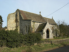
 All Saints' Church | |
Location within Norfolk | |
| Area | 25.52 km2 (9.85 sq mi) |
| Population | 239 (2021) |
| • Density | 9/km2 (23/sq mi) |
| OS grid reference | TF792042 |
| Civil parish |
|
| District | |
| Shire county | |
| Region | |
| Country | England |
| Sovereign state | United Kingdom |
| Post town | SWAFFHAM |
| Postcode district | PE37 |
| Dialling code | 01760 |
| Police | Norfolk |
| Fire | Norfolk |
| Ambulance | East of England |
| UK Parliament | |
Cockley Cley is a village and civil parish in the English county of Norfolk.
Cockley Cley is located 3.2 miles (5.1 km) south-west of Swaffham and 27 miles (43 km) west of Norwich.
History
[edit]The village's name is of Anglo-Saxon origin and derives from the Old English for a "clay hill shrouded in trees".[1]
In the Domesday Book, Cockley Cley is recorded as a settlement of 32 households located in the hundred of South Greenhoe. In 1086, the village was divided between the estates of King William I and William de Warenne.[2]
Cockley Cley is the site of significant defensive infrastructure built during the Second World War, including a rare example of an "Allan Williams Turret" designed to mount a Lewis gun in an anti-aircraft role.[3]
In August 1974, a decapitated corpse of a woman was discovered near the village. As of 2023, the woman has not been identified.[citation needed]
Between 1975 and 2004, Cockley Cley was home to a mock Iceni village visitor attraction. The site reopened briefly in 2014 as the Iceni Centre but was subsequently forced to close due to dwindling customer numbers.[4]
Geography
[edit]According to the 2021 census, Cockley Cley has a population of 239 people which shows a slight increase from the 232 people recorded in the 2011 census.[5]
The River Gadder rises close to Cockley Cley.
All Saints' Church
[edit]Cockley Cley's parish church is one of Norfolk's 124 existing Anglo-Saxon round-tower churches, and thus dates from the Thirteen Century. All Saints' is located on Swaffham Road and has been Grade II listed since 1960.[6]
The churchtower collapsed on 29 August 1991 and has not been re-built with much of the remaining building dating from a restoration and rebuilding in the Victorian era under the architect, Richard Phipson.[7]
Governance
[edit]Cockley Cley is part of the electoral ward of Bedingfield for local elections and is part of the district of Breckland.
The village's national constituency is South West Norfolk which has been represented by Labour's Terry Jermy since 2024.
War Memorial
[edit]Cockley Cley's war memorial is a marble plaque located inside All Saints' Church which lists the following names for the First World War:[8]
| Rank | Name | Unit | Date of Death | Burial |
|---|---|---|---|---|
| Cpl. | William B. Root | 8th Bn., Norfolk Regiment | 21 Jul. 1916 | Thiepval Memorial |
| Cpl. | Frederick Atter | 9th Bn., Norfolk Regt. | 19 May 1917 | Barlin Cemetery |
| LCpl. | Frederick C. Barker | 1st Bn., Essex Regiment | 1 Nov. 1915 | Alexandria War Cemetery |
| LCpl. | Wallace G. DeRungary | 1st Bn., Norfolk Regiment | 1 Sep. 1918 | Achiet-le-Grand Cemetery |
| Pte. | Edward C. Pedgrift | 8th Bn., Norfolk Regt. | 4 Jun. 1915 | St. Lawrence's Churchyard |
| Pte. | Charles R. Wilding | 8th Bn., Norfolk Regt. | 5 Dec. 1915 | Norfolk Cemetery |
And, Frederick Diaper and Henry W. T. Norman as well as the following for the Second World War:
| Rank | Name | Unit | Date of Death | Burial |
|---|---|---|---|---|
| Mne. | Sydney A. Holman | H.M. Landing Craft (Flak) L14 | 24 May 1944 | Chatham Naval Memorial |
| Pte. | Russell K. Pigg | 2nd Bn., Royal Norfolk Regiment | 26 May 1940 | Mont-Bernanchon Cemetery |
Gallery
[edit]-
Cockley Cley village sign, showing the church still with its tower
-
Rare Allan Williams Turret fortifications of World War II in Cockley Cley
-
Entrance to the reconstruction of an Iceni village, now closed
References
[edit]- ^ "Key to English Place-names". kepn.nottingham.ac.uk. Retrieved 16 October 2024.
- ^ "[Cockley] Cley | Domesday Book". opendomesday.org. Retrieved 16 October 2024.
- ^ "World-War-Two-Allan-Williams-Turret - Norfolk Heritage Explorer". www.heritage.norfolk.gov.uk. Retrieved 16 October 2024.
- ^ "Iceni Centre, formerly the Iceni Village, closes despite attempted revival". Eastern Daily Press. 15 July 2014. Retrieved 16 October 2024.
- ^ "Cockley Cley (Parish, United Kingdom) - Population Statistics, Charts, Map and Location". www.citypopulation.de. Retrieved 13 December 2024.
- ^ "CHURCH OF ALL SAINTS, Cockley Cley - 1077261 | Historic England". historicengland.org.uk. Retrieved 13 December 2024.
- ^ "Norfolk Churches". www.norfolkchurches.co.uk. Retrieved 13 December 2024.
- ^ "Geograph:: Caister to Croxton :: War Memorials in Norfolk". www.geograph.org.uk. Retrieved 13 December 2024.


