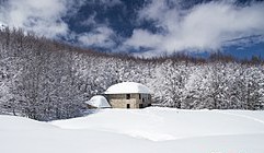
Cervati
Appearance
You can help expand this article with text translated from the corresponding article in Italian. (May 2010) Click [show] for important translation instructions.
|
| Cervati | |
|---|---|
 | |
| Highest point | |
| Elevation | 1,898 m (6,227 ft) |
| Prominence | 1,344 m (4,409 ft)[1] |
| Listing | Ribu |
| Coordinates | 40°16′N 15°28′E / 40.267°N 15.467°E |
| Geography | |
| Location | Province of Salerno (Campania, Italy) |
| Parent range | Lucan Subappennines |
| Geology | |
| Mountain type | Extinct volcano |
Cervati or Monte Cervati is an Italian mountain of the Province of Salerno, Campania.
Geography
[edit]The mountain is located in the north-western side of the municipality of Sanza, close to the forest area of Pruno.[2] It is the source of the river Bussento.
With 1,898 amsl it is the highest mountain of Cilento, followed by Panormo (part of Alburni range, 1,742 amsl), Faiatella (1,710) and Gelbison (1,705). It is also the second highest mountain of Campania, after the Monte Miletto of Matese (2,050), located partly in Molise.[3][4]
Geology
[edit]Cervati is an extinct volcano. [5] The last eruption from the volcano is unknown.
See also
[edit]References
[edit]- ^ https://worldribus.org/italian-peninsula-and-islands/
- ^ "Il Cervati". CilentoMtb (in Italian).
- ^ "Monte Cervati - Peakbagger.com". www.peakbagger.com. Retrieved 2023-04-21.
- ^ "Nevera Monte Cervati 1898 metri". digilander.libero.it (in Italian). Retrieved 2023-04-21.
- ^ "Monte Cervati : Climbing, Hiking & Mountaineering : SummitPost". Summit Post.
External links
[edit]![]() Media related to Cervati at Wikimedia Commons
Media related to Cervati at Wikimedia Commons

