Castelré
Castelré | |
|---|---|
Village | |
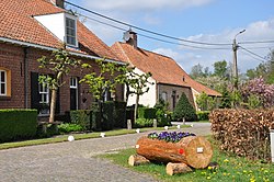
 Farms in Castelré | |
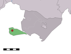
 Location within Baarle-Nassau municipality of Castelré village (red dot) and statistical district (light green area) | |
| Coordinates: 51°25′31″N 04°46′50″E / 51.42528°N 4.78056°E | |
| Country | |
| Province | North Brabant |
| Municipality | Baarle-Nassau |
| Area | |
• Total | 6.67 km2 (2.58 sq mi) |
| Elevation | 16 m (52 ft) |
| Population (2021)[1] | |
• Total | 120 |
| • Density | 18/km2 (47/sq mi) |
| Time zone | UTC+1 (CET) |
| • Summer (DST) | UTC+2 (CEST) |
| Postal code | 5114[1] |
| Dialing code | 013 |
| Website | Gemeentesite |
Castelré (Dutch pronunciation: [ˌkɑstəlˈreː]) is a village in the Dutch province of North Brabant. It is a part of the municipality of Baarle-Nassau, and lies some 20 km south of Breda.
In 2000 a millennium chapel was built at the "Kempische-driehoek" 't Groesje.
Castelré belongs to the parish of Sint-Clemenskerk, Minderhout.[3] As Minderhout is a Belgian village in the community of Hoogstraten only a few hundred metres to the west, people are more oriented to Minderhout than to their official municipality of Baarle-Nassau, over 10 km to the east.
History
[edit]The village was first mentioned in 1231 as "de molendino de Casterle". The etymology is unclear.[4]
Castelré was home to 305 people in 1840.[3] In 1970, a monument was unveiled for the first air balloon to land in the Netherlands. The balloon was launched in 1870 in Paris, and supposed to land in France.[3] In 1978, the village was entered in the postal database as Castelre without an accent. As of 2022, it has not been corrected.[5]
Gallery
[edit]-
Monument to the air balloon landing
-
Farm in Castelré
-
Street view
References
[edit]- ^ a b c "Kerncijfers wijken en buurten 2021". Central Bureau of Statistics. Retrieved 15 April 2022.
- ^ "Postcodetool for 5114AA". Actueel Hoogtebestand Nederland (in Dutch). Het Waterschapshuis. Retrieved 15 April 2022.
- ^ a b c "Castelré". Plaatsengids (in Dutch). Retrieved 15 April 2022.
- ^ "Castelré - (geografische naam)". Etymologiebank (in Dutch). Retrieved 15 April 2022.
- ^ "Postcode 5114 in Castelre". Postcode bij adres (in Dutch). Retrieved 15 April 2022.


