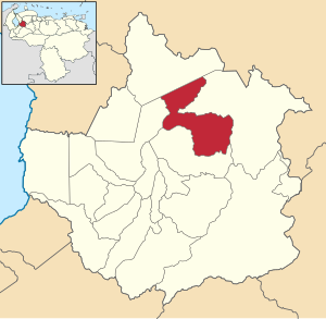
Candelaria Municipality, Trujillo
Appearance
Candelaria Municipality
Municipio Candelaria | |
|---|---|
 Location in Trujillo | |
| Coordinates: 9°37′05″N 70°21′26″W / 9.61806°N 70.35722°W | |
| Country | |
| State | Trujillo |
| Established | 6 August 1988 |
| Municipal seat | Chejendé |
| Government | |
| • Mayor | Carmen Elena Benítez (PSUV) |
| Area | |
| • Total | 411 km2 (159 sq mi) |
| Population (2011) | |
| • Total | 27,811[1] |
| Time zone | UTC−4 (VET) |
Candelaria is one of the 20 municipalities of the state of Trujillo, Venezuela. The municipality occupies an area of 411 km2 with a population of 27,811 inhabitants according to the 2011 census.
Parishes
[edit]The municipality consists of the following seven parishes, with their capitals listed in parentheses:
- Arnoldo Gabaldón (Minas)
- Bolivia (Bolivia)
- Carrillo (Torococo)
- Cegarra (Mitón)
- Chejendé (Chejendé)
- Manuel Salvador Ulloa (Sabana Grande)
- San José (Las Llanadas)
References
[edit]- ^ "Resultados por entidad federal y municipios del Estado Trujillo" (PDF). Censo nacional de población y vivienda 2011. INE. December 2014. Archived from the original (PDF) on 26 November 2021. Retrieved 25 November 2021.


