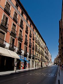
Calle Mayor (Madrid)
 | |
| Type | street |
|---|---|
| Location | Madrid, Spain |
| East end | Puerta del Sol |
| West end | Cuesta de la Vega |
The Calle Mayor is a centric street in Madrid, Spain. Located in the Centro District, the Calle Mayor starts in the Puerta del Sol and ends at the cuesta de la Vega.[1]
History
[edit]Created in the Middle Ages it originally connected the alcázar with the Puerta de Guadalajara (a disappeared wall gate).[2] The Calle Mayor, that borders the Plaza Mayor to the North, became the main thoroughfare of the city in the Early Modern Period.[3] The Calle Mayor was the place where the guilds of silversmiths and jewelers concentrated.[4] In the 18th century, the street was divided in three sections with different names: Almudena (from the alcázar surroundings to the Plazuela de la Villa; Platería (from the plazuela de la Villa to the Puerta de Guadalajara), and Mayor (from the Puerta de Guadalajara to the Puerta del Sol).[5][6]
References
[edit]- ^ "Callejero Oficial del Ayuntamiento de Madrid. 2015" (PDF). Ayuntamiento de Madrid.
- ^ Sambricio 1996, p. 29.
- ^ Escobar 2004, pp. 374–375.
- ^ Jiménez Priego 1997, p. 94.
- ^ Sambricio 2002, p. 104.
- ^ Peñasco de la Puente & Cambronero 1889, pp. 321–326.
Bibliography
[edit]- Peñasco de la Puente, Hilario; Cambronero, Carlos (1889). Las calles de Madrid: noticias, tradiciones y curiosidades. Madrid: Establecimiento tipográfico de D. Enrique Rubiños. pp. 321–326.
- Escobar, Jesús (2004). "Francisco De Sotomayor and Nascent Urbanism in Sixteenth-Century Madrid". The Sixteenth Century Journal. 35 (2): 357–382. doi:10.2307/20476940. JSTOR 20476940.
- Jiménez Priego, María Teresa (1997). "Perfil del joyero". Espacio Tiempo y Forma. Serie VII, Historia del Arte. 10 (10). Madrid: Universidad Nacional de Educación a Distancia: 59–110. doi:10.5944/etfvii.10.1997.2295. ISSN 1130-4715.
- Sambricio, Carlos (1996). "Una propuesta urbana para la Calle Mayor" (PDF). Arquitectura (307). Madrid: Colegio Oficial de Arquitectos de Madrid: 29–38. ISSN 0004-2706.
- Sambricio, Carlos (2002). "Un proyecto fracasado: las transformaciones de la calle Mayor en el siglo XVIII". Historia Contemporánea (24). Bilbao: University of the Basque Country. ISSN 1130-2402.
