Caithness Lochs
| Caithness Lochs | |
|---|---|
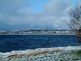
 Loch Watten, one of the Caithness Lochs | |
 | |
| Location | Highland, Scotland |
| Coordinates | 58°29′30″N 3°20′00″W / 58.491667°N 3.33333°W |
| Area | 13.79 km2 (5.32 sq mi)[1] |
| Established | 1998 (extended 2000) |
| Governing body | Scottish Natural Heritage (SNH) |
Caithness Lochs is a protected wetland area in the historic county of Caithness in the far north of Scotland. With a total area of 1,379 hectares, it covers six freshwater lochs and a complex area of fen and swamp, and has been protected as a Ramsar Site since 1998.[2]
The area comprises seven distinct wetlands, each of which is a Site of Special Scientific Interest: Broubster Leans, Loch of Mey, Loch Calder, Loch Heilen, Loch of Wester, Loch Scarmclate and Loch Watten. These provide a variety of habitats for waterfowl and wading birds, including internationally important populations of greylag geese, white-fronted geese and whooper swans.[1] It is also important for several species of reed, pondweed and water sedge.[3]
As well as being recognised as a wetland of international importance under the Ramsar Convention,[2] Caithness Lochs has also has been designated a Special Protection Area and a Special Area of Conservation.[1][4]
References
[edit]- ^ a b c "Caithness Lochs SPA". Joint Nature Conservation Committee. Retrieved 13 February 2019.
- ^ a b "Caithness Lochs". Ramsar Sites Information Service. Retrieved 13 February 2019.
- ^ "UK Caithness Lochs" (PDF). Ramsar Sites Information Service. Retrieved 13 February 2019.
- ^ "Caithness Lochs SPA". Scottish Natural Heritage. Retrieved 13 February 2019.
