Sengerema District
Sengerema
Halmashauri ya Wilaya ya Sengerema (Swahili) | |
|---|---|
 Lake Victoria Sunset in Sengerema | |
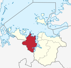
 Sengerema District's location within Mwanza Region. | |
| Coordinates: 02°20′S 032°30′E / 2.333°S 32.500°E | |
| Country | |
| Region | Mwanza Region |
| District | Sengerema District |
| Headquarters[1] | Sengerema town |
| Government | |
| • Type | Council |
| • Chairman | Yanga Makaga |
| • Director | Binuru M. Shekidere |
| Area | |
• District | 1,842 km2 (711 sq mi) |
| Elevation | 1,400 m (4,600 ft) |
| Population (2022 census)[2] | |
• District | 425,415 |
| • Density | 230/km2 (600/sq mi) |
| • Urban | 117,030 |
| Time zone | EAT |
| Postcode[3] | 333xx |
| Area code | 028 |
| UFI | -2573399 |
| Website | District Website |
Sengerema District is one of seven districts in the Mwanza Region of Tanzania, East Africa. Its administrative headquarter is located in Sengerema city.[4] It is bordered to the north and east by Lake Victoria, to the south by Geita Region and to the southeast by the Misungwi District. Sengerema district is known for having numerous lake islands in its territory the largest are Maisome Island and Kome Island.
Demographics
[edit]In 2016 the Tanzania National Bureau of Statistics report there were 377,649 people in the district, from 663,034 in 2012.[5]: 147 [6]: 178
Administrative subdivisions
[edit]Sengerema District is divided into 3 divisions, 26 wards, 71 villages and 421 hamlets (vitongoji).[5]: 147 [7]
Constituencies
[edit]For parliamentary elections, Tanzania is divided into constituencies. As of the 2010 elections Sengerema District had two constituencies:[8]
- Buchosa Constituency
- Sengerema Constituency
Wards
[edit]Ward (2016 Population)[5]: 147
- Bitoto (5,904)
- Busisi (8,281)
- Buyagu (11,537)
- Buzilasoga (15,035)
- Chifunfu (26,337)
- Ibisabageni (14,932)
- Ibondo (1,691)
- Igalula (21,234)
- Igulumuki (10,096)
- Kagunga (22,322)
- Kahumulo (10,686)
- Kasenyi (17,562)
- Kasungamile (17,571)
- Katunguru (22,848)
- Kishinda (13,902)
- Mission (9,909)
- Mwabaluhi (12,215)
- Ngoma (11,070)
- Nyamatongo (19,013)
- Nyamazugo (11,381)
- Nyamizeze (7,039)
- Nyampande (10,781)
- Nyampulukano (25,175)
- Nyatukala (22,715)
- Sima (17,434)
- Tabaruka (10,979)
References
[edit]- ^ "Historia". sengeremadc.go.tz (in English and Swahili). Sengerema town: Halmashauri ya Wilaya ya Sengerema. Archived from the original on 20 June 2022. Retrieved 18 August 2022.
- ^ Citypopulation.de
- ^ "Mwanza Postcodes" (PDF). Tanzania Communications Regulatory Authority. Archived (PDF) from the original on 29 July 2022. Retrieved 9 August 2022.
- ^ "History of Sengerema District Council". Sengerema District Council. Retrieved 30 March 2022.
- ^ a b c 2016 Makadirio ya Idadi ya Watu katika Majimbo ya Uchaguzi kwa Mwaka 2016, Tanzania Bara [Population Estimates in Administrative Areas for the Year 2016, Mainland Tanzania] (PDF) (Report) (in Swahili). Dar es Salaam, Tanzania: National Bureau of Statistics. 2016-04-01. Archived (PDF) from the original on 2021-12-27. Retrieved 2022-07-03.
- ^ 2012 Population and Housing Census - Population Distribution by Administrative Areas (PDF) (Report). Dar es Salaam, Tanzania: National Bureau of Statistics. 2013-03-01. Archived (PDF) from the original on 2022-03-26. Retrieved 2022-07-03.
- ^ "Takwimu". sengeremadc.go.tz (in Swahili). Halmashauri ya Wilaya ya Sengerema. Archived from the original on 20 June 2022. Retrieved 18 August 2022.
- ^ "Organisations located in Sengerema District - Tanzania". African Development Information.
