Brno-Jehnice
This article relies largely or entirely on a single source. (October 2022) |
Brno-Jehnice | |
|---|---|
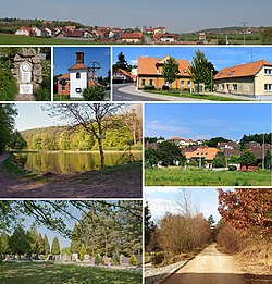
 • Above: View of Jehnice from the south • Left 1 (left): Monument to the victims of wars | |
 Location of Brno-Jehnice in Brno | |
| Coordinates: 49°16′16″N 16°35′46″E / 49.27111°N 16.59611°E | |
| Country | Czech Republic |
| Region | South Moravian Region |
| City | Brno |
| Government | |
| • Mayor | Oto Rinchenbach |
| Area | |
• Total | 4.07 km2 (1.57 sq mi) |
| Population (2023)[1] | |
• Total | 1,136 |
| • Density | 280/km2 (720/sq mi) |
| Time zone | UTC+1 (CET) |
| • Summer (DST) | UTC+2 (CEST) |
| Postal code | 621 00 |
| Website | http://brno-jehnice.cz/ |
Brno-Jehnice is a city district of Brno in the Czech Republic. It is made up of the municipal part and cadastral territory of Jehnice, originally an independent municipality that became a part of Brno in 1971. Its cadastral territory has an area of 4.07 km² and about 1,100 inhabitants.
The first possible mention of Jehnice dates from 1292, in the following centuries the village belonged mainly to the Lichtenburgs and mainly to the Boskovices. Their property was acquired by the Liechtenstein family at the beginning of the 17th century. A part of the village has been a free manor since the Middle Ages, which was also purchased by the Lichtensteins at the end of the 18th century. In 1801, a small independent estate was created from Jehnice and Mokrá Hora, gradually with different owners. From the middle of the 19th century, Jehnice was an independent municipality, and in 1971 it became part of Brno. At the turn of the 20th and 21st centuries, a more extensive suburban development arose here.
Due to its forest character, the Jehnice area is used as a tourist and recreational facility for the residents of Brno. On the road to Vranov there is a listed church of God's torment, right in the village there is a bell tower and several other sights.
Demographics
[edit]| Year | Pop. | ±% |
|---|---|---|
| 1869 | 271 | — |
| 1880 | 293 | +8.1% |
| 1890 | 342 | +16.7% |
| 1900 | 397 | +16.1% |
| 1910 | 460 | +15.9% |
| 1921 | 502 | +9.1% |
| 1930 | 675 | +34.5% |
| 1950 | 658 | −2.5% |
| 1961 | 656 | −0.3% |
| 1970 | 630 | −4.0% |
| 1980 | 614 | −2.5% |
| 1991 | 532 | −13.4% |
| 2001 | 752 | +41.4% |
| 2011 | 1,102 | +46.5% |
| 2021 | 1,090 | −1.1% |
| Source: Censuses[2][3] | ||
References
[edit]- ^ "Participative budget in the city districts of Brno" (in Czech). Czech Statistical Office. 2023-01-01.
- ^ "Historický lexikon obcí České republiky 1869–2011 – Okres Brno-město" (PDF) (in Czech). Czech Statistical Office. 2015-12-21.
- ^ "Population Census 2021: Population by sex". Public Database. Czech Statistical Office. 2021-03-27.


