Brimpaen
Appearance
| Brimpaen Victoria | |
|---|---|
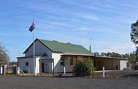
 The public hall at Brimpaen | |
| Coordinates | 37°03′28″S 142°21′6″E / 37.05778°S 142.35167°E |
| Population | 80 (2016 census)[1] |
| Postcode(s) | 3400 |
| Location | |
| LGA(s) | Rural City of Horsham |
| State electorate(s) | Ripon |
| Federal division(s) | Wannon |
Brimpaen is a locality situated in the Wimmera region of western Victoria, Australia. The Henty Highway between Mildura and Portland passes through the locality. At the 2021 census, Brimpaen and the surrounding area had a population of 80.[1]
Brimpaen Post Office opened on 1 May 1886 and closed in September 1957.[2]
References
[edit]- ^ a b "2021 Brimpaen, Census All persons QuickStats | Australian Bureau of Statistics". Australian Bureau of Statistics. Retrieved 28 June 2022.
- ^ Phoenix Auctions History, Post Office List, retrieved 28 February 2021
External links
[edit]![]() Media related to Brimpaen at Wikimedia Commons
Media related to Brimpaen at Wikimedia Commons


