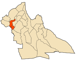
Brida District
Appearance
Brida District
دائرة بريدة | |
|---|---|
 Map of Algeria highlighting Laghouat Province | |
 Map of Laghouat Province highlighting Brida District | |
| Coordinates: 33°58′N 1°44′E / 33.967°N 1.733°E | |
| Country | |
| Province | Laghouat |
| District seat | Brida |
| Population (2008[1]) | |
• Total | 15,924 |
| Time zone | UTC+01 (CET) |
| Municipalities | 3 |
Brida is a district in Laghouat Province, Algeria. It was named after its capital, Brida.
Municipalities
[edit]The district is further divided into 3 municipalities:[2]
- Brida
- Hadj Mechri
- Taouiala. In Taouïala (تاوياله), located in the Amour Range to the southeast of Aflou, there is an ecotouristic village.[3]
References
[edit]- ^ "Wilaya de Laghouat: répartition de la population résidente des ménages ordinaires et collectifs, selon la commune de résidence et la dispersion" (PDF) (in French). Archived (PDF) from the original on 2011-11-13. Retrieved 2019-11-03.. Data from the 2008 General Population and Housing Census on the site of the NOS Algeria.
- ^ "Décret executif n° 91-306 du 24 août 1991 fixant la liste des communes animées par chaque chef de daïra. 03 - Wilaya de Laghouat" [List of municipalities animated by each District chief: 03 - Laghouat Province] (PDF) (in French). Journal officiel de la République Algérienne. 4 September 1991. p. 1294. Archived (PDF) from the original on 2019-10-25. Retrieved 2019-11-03.
- ^ Village éco-touristique solidaire à Taouiala wilaya de Laghouat

