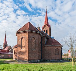
Brójce, Lubusz Voivodeship
Appearance
Brójce | |
|---|---|
Village | |
 Holy Name of Mary church in Brójce | |
| Coordinates: 52°18′N 15°40′E / 52.300°N 15.667°E | |
| Country | |
| Voivodeship | Lubusz |
| County | Międzyrzecz |
| Gmina | Trzciel |
| Population | |
| • Total | 1,050 |
| Time zone | UTC+1 (CET) |
| • Summer (DST) | UTC+2 (CEST) |
| Vehicle registration | FMI |
| Website | brojce.net |
Brójce [ˈbrui̯t͡sɛ] is a village in the administrative district of Gmina Trzciel, within Międzyrzecz County, Lubusz Voivodeship, in western Poland.[1] It lies approximately 17 kilometres (11 mi) south-west of Trzciel, 18 km (11 mi) south of Międzyrzecz, 42 km (26 mi) north of Zielona Góra, and 56 km (35 mi) south-east of Gorzów Wielkopolski.
Brójce was a royal town of the Kingdom of Poland, administratively located in the Kościan County in the Poznań Voivodeship in the Greater Poland Province of the Kingdom of Poland.[2]
References
[edit]- ^ "Central Statistical Office (GUS) - TERYT (National Register of Territorial Land Apportionment Journal)" (in Polish). 2008-06-01.
- ^ Atlas historyczny Polski. Wielkopolska w drugiej połowie XVI wieku. Część I. Mapy, plany (in Polish). Warszawa: Instytut Historii Polskiej Akademii Nauk. 2017. p. 1a.
External links
[edit]- Jewish Community in Brójce on Virtual Shtetl


