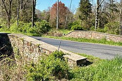
Bowne Station Road stone arch bridge over tributary of the Alexauken Creek
Bowne Station Road stone arch bridge over tributary of the Alexauken Creek | |
 | |
| Location | Bowne Station Road over tributary of the Alexauken Creek, Bowne, New Jersey |
|---|---|
| Coordinates | 40°25′11.2″N 74°54′47.9″W / 40.419778°N 74.913306°W |
| Built | 1837 |
| MPS | Historic Bridges of Delaware Township, Hunterdon County, New Jersey MPDF |
| NRHP reference No. | 100010172[1][2] |
| NJRHP No. | 5875[3] |
| Significant dates | |
| Added to NRHP | April 11, 2024 |
| Designated NJRHP | February 22, 2024 |
The Bowne Station Road stone arch bridge over tributary of the Alexauken Creek is located in the Bowne section of Hunterdon County, New Jersey, United States. It is on the boundary between Delaware Township and East Amwell Township. Built in 1837, the stone arch bridge was added to the National Register of Historic Places on April 11, 2024, for its significance in engineering and transportation.[4] It was listed as part of the Historic Bridges of Delaware Township, Hunterdon County, New Jersey Multiple Property Submission (MPS).[5]
The bridge was originally built in 1837, as noted by the datestone in the east parapet wall. Sandstone from the underlying Stockton Formation was used in its construction. It was widened in 1938, with a new west parapet wall and barrel vault. The area is named after Dr. John Bowne (1767–1857) who lived nearby. In 1854, the Flemington Railroad and Transportation Company built a railroad between Flemington and Lambertville, with a station located here, known as Bowne Station.[4]

See also
[edit]- National Register of Historic Places listings in Hunterdon County, New Jersey
- List of bridges on the National Register of Historic Places in New Jersey
References
[edit]- ^ "National Register Information System – (#100010172)". National Register of Historic Places. National Park Service. November 2, 2013.
- ^ "Weekly List 2024 04 12". National Park Service. April 12, 2024.
- ^ "New Jersey and National Registers of Historic Places – Hunterdon County" (PDF). New Jersey Department of Environmental Protection – Historic Preservation Office. March 25, 2024. p. 4.
- ^ a b Cielo, Carla (April 2023). National Register of Historic Places Registration: Bowne Station Road stone-arch bridge over tributary of the Alexauken Creek (Draft) (PDF). National Park Service. With accompanying 9 photos.
- ^ Scott, Caroline Charlese; Cielo, Carla; Kinney, Jonathan (July 2016). "Historic Bridges of Delaware Township, Hunterdon County, New Jersey". National Park Service.
External links
[edit] Media related to Bowne Station Road stone arch bridge over tributary of the Alexauken Creek at Wikimedia Commons
- Delaware Township, Hunterdon County, New Jersey
- East Amwell Township, New Jersey
- Bridges completed in 1837
- Stone arch bridges in the United States
- Bridges in Hunterdon County, New Jersey
- National Register of Historic Places in Hunterdon County, New Jersey
- Road bridges on the National Register of Historic Places in New Jersey
- New Jersey Register of Historic Places
- 1837 establishments in New Jersey


