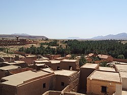
Boussemghoun
Appearance
Boussemghoun
بلدية بوسمغون | |
|---|---|
| Commune of Boussemghoun | |
 | |
 Location of Boussemghoun within El Bayadh Province | |
| Coordinates: 32°52′N 0°01′E / 32.867°N 0.017°E | |
| Country | |
| Province | El Bayadh |
| District | Boussemghoun (coextensive) |
| Government | |
| • PMA Seats | 7 |
| Area | |
• Total | 585 km2 (226 sq mi) |
| Elevation | 1,199 m (3,934 ft) |
| Population (1998) | |
• Total | 2,480 |
| • Density | 4.2/km2 (11/sq mi) |
| Time zone | UTC+01 (CET) |
| Postal code | 32320 |
| ONS code | 3213 |
Boussemghoun (Arabic: بوسمغون) is a municipality in El Bayadh Province, Algeria. It is co-extensive with the district of Boussemghoun, and has a population of 2,480 which gives it 7 seats in the PMA. Its postal code is 32320 and its municipal code is 3213.
The people of Boussemghoun speak a Berber dialect, locally termed "Chelha" or "Tachelhit"; as of 2004, this remained in regular use, in contrast with some neighbouring villages where the use of Berber is reported to be declining.[1] The oasis is a centre of the Tijaniyyah order, which was founded there by Sidi Ahmad al-Tijani in 1782; it has a Tijaniyyah zaouia.[2]
The earliest known historical mention of Boussemghoun is by Ibn Khaldun, in reference to a raid in 1370.[3]
References
[edit]


