Borough of Eaglehawk
| Borough of Eaglehawk Victoria | |
|---|---|
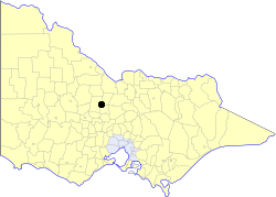
 Location in Victoria | |
 Town hall at Brassey Square | |
| Population | 8,800 (1992)[1] |
| • Density | 605/km2 (1,568/sq mi) |
| Established | 1862 |
| Area | 14.54 km2 (5.6 sq mi) |
| Council seat | Eaglehawk |
| Region | North Central Victoria |
| County | Bendigo |
 | |
The Borough of Eaglehawk was a local government area which covered the northwestern suburbs of the regional city of Bendigo, Victoria, Australia. The borough covered an area of 14.54 square kilometres (5.6 sq mi) and existed from 1862 until 1994.
History
[edit]Eaglehawk was first incorporated as a borough on 29 July 1862. It had nine councillors, who represented the entire borough.[2]
On 7 April 1994, the Borough of Eaglehawk was abolished and, along with the City of Bendigo, the Rural City of Marong and the shires of Huntly and Strathfieldsaye, was merged into the newly created City of Greater Bendigo.[3][4]
Councillors met at the town hall, at the intersection of Sailors Gully Road and Loddon Valley Highway, Eaglehawk.
Population
[edit]| Year | Population |
|---|---|
| 1954 | 4,696 |
| 1958 | 5,000* |
| 1961 | 4,926 |
| 1966 | 5,230 |
| 1971 | 5,383 |
| 1976 | 6,447 |
| 1981 | 7,355 |
| 1986 | 8,184 |
| 1991 | 8,381 |
* Estimate in the 1958 Victorian Year Book.
List of mayors
[edit]References
[edit]- ^ Australian Bureau of Statistics, Victoria Office (1994). Victorian Year Book. p. 52. ISSN 0067-1223.
- ^ Victorian Municipal Directory. Brunswick: Arnall & Jackson. 1992. p. 548. Accessed at State Library of Victoria, La Trobe Reading Room.
- ^ Municipal Association of Victoria (2006). "Greater Bendigo City Council". Archived from the original on 17 January 2008. Retrieved 8 January 2008. Date cross-checked with the Records Division, Greater Bendigo City Council.
- ^ Taylor, Thomas (6 April 1994). "Marong to fall in line on super council". The Age. p. 6. Accessed via Factiva online.
