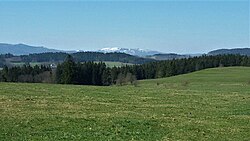
Boletice Military Training Area
Boletice | |
|---|---|
 Knížecí stolec, the highest point of Boletice | |
| Coordinates: 48°49′30″N 14°13′2″E / 48.82500°N 14.21722°E | |
| Country | |
| Region | South Bohemian |
| District | Český Krumlov |
| First mentioned | 1263 |
| Area | |
• Total | 165.44 km2 (63.88 sq mi) |
| Elevation | 620 m (2,030 ft) |
| Population (2024-01-01)[1] | |
• Total | 0 |
| Time zone | UTC+1 (CET) |
| • Summer (DST) | UTC+2 (CEST) |
| Postal code | 382 08 |
| Website | www |
Boletice Military Training Area (Czech: Vojenský újezd Boletice) is a military training area in Český Krumlov District in the South Bohemian Region of the Czech Republic. Half of the military area is located in the Bohemian Forest range.
Geography
[edit]Boletice Military Training Area is located about 9 kilometres (6 mi) west of Český Krumlov and 25 km (16 mi) southwest of České Budějovice. It lies on the border with Austria. The western part of the military area lies in the Bohemian Forest and most of it belongs into the Šumava Protected Landscape Area. The eastern part lies in the Bohemian Forest Foothills. The highest point is the mountain Knížecí stolec at 1,236 m (4,055 ft) above sea level. The lowest point is the riverbed on the stream Boletický potok at 542 m (1,778 ft). The Blanice River originates in the territory of the milutary training area.
History
[edit]Boletice Military Training Area was established on 19 May 1947 as the successor of the Boletice Military Camp. On 1 January 2016, its area was reduced by a quarter. Two new municipalities were established: Polná na Šumavě (including the settlements of Květušín, Olšina and Otice) and Křišťanov. In addition, the village of Boletice, after which the military area is named, was joined to Kájov, and Třebovice was joined to Ktiš. Since then, no permanent residents have lived here.[2]
Except for the settlements that separated from the military area in 2016, the following villages and hamlets were located in its territory before the establishment of the military area: Arnoštov, Beníkovice, Bezděkov, Bílovice, Bláto, Bozdova Lhota, Břevniště, Chlumany, Dolní Brzotice, Hořičky, Horní Brzotice, Hvozd, Jablonec, Javoří, Květná, Lomek, Loutka, Míšňany, Mladoňov, Nová Víska, Nový Špičák, Ondřejov, Osí, Polečnice, Podvoří, Pražačka, Račín, Sádlno, Šavlova Lhota, Starý Špičák, Střemily, Strouhy, Uhlíkov, Veselí, Vitěšovice, Vítěšovičtí Uhlíři, Vlčí Jámy, Vražice, Zadní Bor and Zlatá.[3]
Demographics
[edit]
|
|
| ||||||||||||||||||||||||||||||||||||||||||||||||||||||
| Source: Censuses[3][4] | ||||||||||||||||||||||||||||||||||||||||||||||||||||||||
Access
[edit]According to the laws of the Czech Republic, access to the entire area without permission is prohibited.[5]
References
[edit]- ^ "Population of Municipalities – 1 January 2024". Czech Statistical Office. 2024-05-17.
- ^ "Vojenský újezd Boletice se zmenší o čtvrtinu. Ocení to motoristé, houbaři i turisté" (in Czech). Budějcká drbna. 2015-12-28. Retrieved 2024-03-26.
- ^ a b "Historický lexikon obcí České republiky 1869–2011" (in Czech). Czech Statistical Office. 2015-12-21.
- ^ "Population Census 2021: Population by sex". Public Database. Czech Statistical Office. 2021-03-27.
- ^ "Titulní stránka" (in Czech). Vojenský újezd Boletice. Retrieved 2024-03-26.


