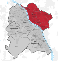
Beuel
Appearance
You can help expand this article with text translated from the corresponding article in German. (August 2019) Click [show] for important translation instructions.
|
Beuel | |
|---|---|
 Beuel on the Rhine riverbank | |
| Coordinates: 50°44′0″N 07°7′20″E / 50.73333°N 7.12222°E | |
| Country | Germany |
| State | North Rhine-Westphalia |
| Admin. region | Cologne |
| District | Urban district |
| City | Bonn |
| Area | |
• Total | 33.2 km2 (12.8 sq mi) |
| Elevation | 54 m (177 ft) |
| Population (2020-12-31)[1] | |
• Total | 67,827 |
| • Density | 2,000/km2 (5,300/sq mi) |
| Time zone | UTC+01:00 (CET) |
| • Summer (DST) | UTC+02:00 (CEST) |
| Dialling codes | 0228 |
| Vehicle registration | BN |
Beuel (Ripuarian: Büel) is a city borough (Stadtbezirk) of Bonn, Germany. It has a population of 67,827 (2020).
Subdivisions
[edit]Beuel is composed of the sub-districts Beuel-Mitte, Beuel-Ost, Geislar, Hoholz, Holtorf, Holzlar, Küdinghoven, Limperich, Oberkassel, Pützchen/Bechlinghoven, Ramersdorf, Schwarzrheindorf/Vilich-Rheindorf, Vilich and Vilich-Müldorf.
Twin towns – sister cities
[edit] Mirecourt, France (1969)
References
[edit]- ^ "Bevölkerung in der Bundesstadt Bonn Stichtag 31.12.2020" (PDF). Bundesstadt Bonn Statistikstelle. Retrieved 28 September 2021.
- ^ "Städtepartnerschaft mit Mirecourt". bonn.de (in German). Bonn. Retrieved 2021-02-10.


