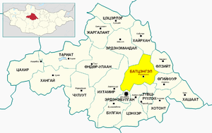
Battsengel
Battsengel District
Батцэнгэл сум ᠪᠠᠲᠤᠴᠡᠩᠭᠡᠯᠰᠤᠮᠤ | |
|---|---|
 Battsengel Sum in Arkhangai Province, Mongolia | |
| Country | Mongolia |
| Province | Arkhangai Province |
| Area | |
• Total | 3,500 km2 (1,400 sq mi) |
| Population (2010) | |
• Total | 3,289 |
| • Density | 1.06/km2 (2.7/sq mi) |
| Time zone | UTC+8 (UTC + 8) |
| Website | http://battsengel.ar.gov.mn/ |
Battsengel (Mongolian: Батцэнгэл, romanized: Batcengel; "Firm happiness") is a sum (district) of Arkhangai Province in central Mongolia. Battsengel is home to approximately 3,289 inhabitants.[1]
History
[edit]Formation of the cape
[edit]In 1696, when the army of Qing, with the participation of Khalkh princes, defeated the army of Galdan Boshgot Khan of Oirad, Namjil, the son of Toba Taiji, a nobleman of Tumenhen, earned the title of Taiji. The governor presented the award. Later, Tumenhen, in recognition of the good efforts of Oirat fighting on behalf of Mr. Manji of Sain noyon's lineage, cut off 19 counties from the territory of the khan province and established the province of Khalkh in 1725.
Modern History
[edit]The 12 Year Secondary School won an award for best school of Arkhangai Aimag in 2012.
References
[edit]- ^ "2010 census results of Mongolia (by district and district)" (PDF). Retrieved 2022-12-16.
47°47′32″N 101°58′26″E / 47.79222°N 101.97389°E

