
Axial, Colorado
Axial, Colorado | |
|---|---|
 Axial Location of Axial, Colorado.  Axial Axial (Colorado) | |
| Coordinates: 40°17′07″N 107°47′31″W / 40.2853°N 107.7920°W[2] | |
| Country | United States |
| State | Colorado |
| County | Moffat[1] |
| Elevation | 6,454 ft (1,967 m) |
| Time zone | UTC−07:00 (MST) |
| • Summer (DST) | UTC−06:00 (MDT) |
| GNIS pop ID | 171423 |
Axial is an extinct coal mining town located in Moffat County, Colorado, United States.[2]
History
[edit]The Axial, Colorado, post office operated from March 6, 1883, until April 30, 1958.[3] The community's central location near the "axis" of mining activity caused the name to be selected.[4]
See also
[edit]- Craig, CO Micropolitan Statistical Area
- List of ghost towns in Colorado
- List of post offices in Colorado
References
[edit]- ^ "Colorado Counties". Colorado Department of Local Affairs. Retrieved January 20, 2025.
- ^ a b c "Axial, Colorado". Geographic Names Information System. United States Geological Survey, United States Department of the Interior. Retrieved December 31, 2024.
- ^ Bauer, William H.; Ozment, James L.; Willard, John H. (1990). Colorado Post Offices 1859–1989. Golden, Colorado: Colorado Railroad Historical Foundation. ISBN 0-918654-42-4.
- ^ Dawson, John Frank (1954). Place names in Colorado: why 700 communities were so named, 150 of Spanish or Indian origin. Denver, CO: The J. Frank Dawson Publishing Co. p. 8.
External links
[edit]Wikimedia Commons has media related to Moffat County, Colorado.
Municipalities and communities of Moffat County, Colorado, United States | ||
|---|---|---|
| City | 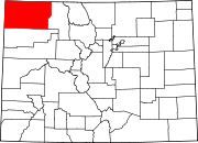 | |
| Town | ||
| CDP | ||
| Unincorporated communities | ||
| Ghost towns | ||
This Colorado state location article is a stub. You can help Wikipedia by expanding it. |
This United States ghost town-related article is a stub. You can help Wikipedia by expanding it. |