Angreau
Appearance
Angreau | |
|---|---|
 Saint Amand's church | |
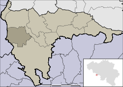
 Location of Angreau in Honnelles | |
| Coordinates: 50°21′05″N 3°41′27″E / 50.35139°N 3.69083°E | |
| Country | |
| Region | |
| Province | |
| Municipality | |
| Postal code | 7387 |
| Area code | 065 |
Angreau (French pronunciation: [ɑ̃ɡʁo]; Walloon: Angrea) is a village of Wallonia and district of the municipality of Honnelles, located in the province of Hainaut, Belgium.
History
[edit]The earliest mention of this locality is Angrellum (Latin: little Angre[1]). In the first Middle Ages, Angreau was part of the stronghold of Angre,[2] of which it was probably an outbuilding with a fortified tower. Angreau has been a commune since the year 1250.[3]

References
[edit]- ^ Debiève, Gilles (2007). Une Dynastie Secrete (in French). Société des Ecrivains. pp. 63, 64.
- ^ de Villers, Victor Doublet (1869). Dictionnaire national belge : historique, biographique, géographique, statistique, artistique, industriel et commercial (in French). Burxelles: Victor Doublet de Villers. p. 46.
- ^ "Angreau", Wikipédia (in French), 2019-10-30, retrieved 2020-01-03
External links
[edit] Media related to Angreau at Wikimedia Commons


