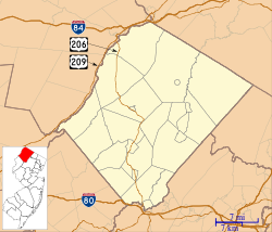
Allamuchy Mountain State Park
| Allamuchy Mountain State Park | |
|---|---|
 Parking lot and entrance area | |
| Location | Allamuchy Township Byram Township |
| Coordinates | 40°55′16.48″N 74°46′56.00″W / 40.9212444°N 74.7822222°W[1] |
| Area | 9,092 acres (36.79 km2) |
| Created | 1966 |
| Operated by | New Jersey Division of Parks and Forestry |
| Website | Official website |
Allamuchy Mountain State Park is located in Allamuchy Township and Byram Township in the Allamuchy Mountain region of New Jersey. The park is operated and maintained by the New Jersey Division of Parks and Forestry. There are more than 20 miles (32 km) of unmarked trails in the northern section of Allamuchy, and 14 miles (23 km) of marked multi-use trails.
The park is in the Northeastern coastal forests ecoregion.[2] The 2,440 acres (9.9 km2) of mixed oak and hardwood forests and maintained fields of this natural area display various stages of succession. It is situated on the Musconetcong River.
Waterloo Village
[edit]
Waterloo Village has exhibits from many different time periods from a 400-year-old Lenape (Delaware) Native American village to a port along the once prosperous Morris Canal. The early 19th-century village contains a working mill with gristmills and sawmills, a general store, a blacksmith shop and restored houses.
Sussex Branch Trail
[edit]
The Sussex Branch Trail, a rail trail on the former Sussex Railroad, has a trail head on Waterloo Road. It travels 3 miles (4.8 km) to Cranberry Lake.[1]
Rutherfurd-Stuyvesant Estate
[edit]The Rutherfurd-Stuyvesant Estate dates back to the 1700s and featured a large mansion and many outbuildings. By the mid 20th century, the mansion had burned down and the remaining buildings were in very poor condition. In the 1960s, the estate was purchased by the State to build route 80, which divided sections of the estate with an eight-lane highway. In the 1970s, the Allamuchy Mountain land became part of Allamuchy Mountain State Park. Tranquillity Farms, on the other side of the highway, remains a privately operated commercial farm.[3][4][5]
Locally, the ruins of the Rutherfurd-Stuyvesant Estate have become known as "Profanity House" because many of the buildings and ruins have been vandalized and covered in explicit and graphic graffiti. In recent years, the estate has suffered from arson damage.[3][4][5]
See also
[edit]References
[edit]- ^ a b "Allamuchy Mountain State Park". New Jersey State Park Service.
- ^ Olson, D. M.; E. Dinerstein; et al. (2001). "Terrestrial Ecoregions of the World: A New Map of Life on Earth". BioScience. 51 (11): 933–938. doi:10.1641/0006-3568(2001)051[0933:TEOTWA]2.0.CO;2. Archived from the original on October 14, 2011.
- ^ a b "Profanity Houses of the Rutherfurd Stuyvesant Estate - Weird NJ". weirdnj.com.
- ^ a b Magazine, Skylands Visitor. "Rutherfurd Hall historical site in Allamuchy, New Jersey". www.njskylands.com.
- ^ a b "Reward being offered for information on 'profanity' house fires". April 30, 2017.


