Aguas Calientes River (Carabobo)
Appearance
| Aguas Calientes | |
|---|---|
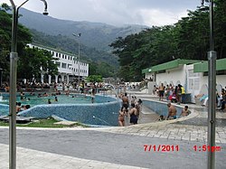
 The spa at Las Trincheras | |
 | |
| Location | |
| Country | Venezuela |
| State | Carabobo |
| Physical characteristics | |
| Source | |
| • location | Las Trincheras |
| Mouth | Caribbean Sea |
• location | Near Puerto Cabello |
• coordinates | 10°28′55″N 68°06′41″W / 10.4819°N 68.1115°W |
Aguas Calientes ("hot waters" in Spanish) is the name of a river in Carabobo state.
Source
[edit]The source is associated with the hot springs of Las Trincheras near Valencia.
Visit of Humboldt
[edit]The springs were visited in 1800 by Alexander von Humboldt, who measured the temperature. He then followed the river down to the Caribbean coast. Humboldt published a scientific description of the springs on his return to Europe. He concluded that they obtained their heat from very deep groundwater circulation.[1][2]
Railway
[edit]The Puerto Cabello and Valencia railway was built in the 1880s following the course of the valley for a considerable part of its route.[3] It closed in the 1950s, but a new railway is under construction.
Mouth
[edit]The river flows into the Caribbean west of Puerto Cabello.
References
[edit]- ^ Davis, S. (1999). Humboldt, Arago, and the temperature of groundwater. Hydrogeology Journal 7: 501. https://doi.org/10.1007/s100400050223
- ^ Navas. Las Trincheras, las segundas mejores aguas termales del mundo
- ^ Chisholm, Hugh, ed. (1911). . Encyclopædia Britannica. Vol. 27 (11th ed.). Cambridge University Press. p. 846.
