Agios Chariton
Appearance
Agios Chariton
Ergenekon | |
|---|---|
| Coordinates: 35°18′18″N 33°36′15″E / 35.30500°N 33.60417°E | |
| Country (de jure) | |
| • District | Famagusta District |
| Country (de facto) | |
| • District | Gazimağusa District |
| Population (2011)[2] | |
• Total | 96 |
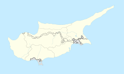
Agios Chariton (Greek: Άγιος Χαρίτων "Saint Chariton"; Turkish: Ergenekon, previously Ayharita) is a small village in Cyprus. It is located 10 kilometres (6.2 mi) north of Marathovounos, on the south side of the Kyrenia mountain range. Agios Chariton is under the de facto control of Northern Cyprus. As of 2011, it had a population of 96. It has historically been a Turkish Cypriot village.[3]
References
[edit]- ^ In 1983, the Turkish Republic of Northern Cyprus unilaterally declared independence from the Republic of Cyprus. The de facto state is not recognised by any UN state except Turkey.
- ^ "KKTC 2011 Nüfus ve Konut Sayımı" [TRNC 2011 Population and Housing Census] (PDF). TRNC State Planning Organization. 6 August 2013. p. 19. Archived from the original (PDF) on 6 November 2013.
- ^ "AGIOS CHARITON". Internal Displacement in Cyprus. PRIO Cyprus Centre. Retrieved 17 January 2015.


